Disclosure : This site contains affiliate links to products. We may receive a commission for purchases made through these links.
Macizo Central de Gredos CNIG
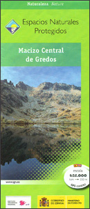
The central section of the Sierra de Gredos on a contoured and GPS compatible map at 1:250,000 from IGN/CNIG using cartography of their civilian topographic survey of Spain. Coverage extends from El Arenal and Arenas se San Pedro westwards to Alisenda de Tormes, and north / south from Navacepeda de Tormes to Candelada.Contours are 10m intervals, enhanced by relief shading plus altitude colouring, with graphics to show different types of vegetation. The map shows prominently highlights waymarked hiking trails and symbols indicate locations of campsites, hostels and paradors, tourist information offices, interesting locations and tree specimens, etc. Road network shows car parks and petrol stations. The map has a 1km UTM grid, plus latitude and longitude lines at 1’ intervals. Map legend includes English. Current edition of this title was published in 2015.

Related Products:
 Macizo de Revolcadores
 Sierra de Gredos: Valles del Alberche y del Tiรฉtar
 Sierra de Gredos – Almanzor – Laguna Grande Editorial Alpina
 Macizo de Monte Perdido – Valle de Ordesa – Pineta Editorial Alpina
 Sierra de Gredos Adrados Map
 Sanabria Lake and Surroundings NP CNIG Map
 Altmรผhl Valley Regional Park: central part
 Central Carinthia – Gurktal Alps – Friesach – Feldkirchen – St. Veit an der Glan F&B WK231
 Valjevo Mountain Range
 Alsace – Vosges Central – Strasbourg – Colmar 2-Map Set Kompass 2221
 Cork Central OSI Discovery 80
 Mayo Central OSI Discovery 31
 Mallorca – Tramuntana Central Editorial Alpina
 Sobrarbe Central – Ainsa – Boltana Editorial Alpina
 Mayo West-Central OSI Discovery 30
 Sierra de Guadarrama National Park 4-Map and Guide Set CNIG
 Mangfallgebirge Central – Spitzingsee – Rotwand Alpenverein BY15
 Spain: Tienda Verde Hiking Maps of Central Spain
 Chiemgau Alps Central – Hochgern – Hochfelln Alpenverein KOMBI BY18
 Central Lycia – Kas and neighbouring Areas
 Picos de Europa National Park 3-Map and Guide Set CNIG ENGLISH
 Picos de Europa National Park 3-Map and Guide Set CNIG SPANISH
 Roztocze Central ExpressMap Tourist Map
Sudetes Central ExpressMap Tourist Map
Roztocze Central ExpressMap Tourist Map
Sudetes Central ExpressMap Tourist Map
 Rodnei Mountains Dimap Hiking Map
 Rajac Mountain
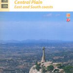 Mallorca Central Plain – East and South Coasts Editorial Alpina
 ร…re Lantmateriet Z51
 Gurghiu Mountains Northern and Central Dimap Hiking Map
 Sรคlen Lantmateriet W54
 Valadalsfjallen Lantmateriet Z53
 Kiruna Lantmateriet BD4
 Idre Lantmateriet W52
 Lofsdalen Lantmateriet Z60
 Oviksfjรคllen Lantmateriet Z55
 Sylarna – Helags Lantmateriet Z54
 Arjeplog Lantmateriet BD12
 Fulufjรคllet Lantmateriet W53
 Sonfjรคllet Lantmateriet Z61
 Altmuhltal NP Central UK50-24