Disclosure : This site contains affiliate links to products. We may receive a commission for purchases made through these links.
Lycksele
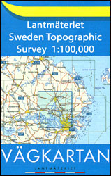
Topographic survey of Sweden at 1:100,000, the Vรคgkartan, from the Lantmรคteriet, covering most of the country in 79 double-sided maps. Please note: the mountainous regions of central and northern Sweden are not covered by this series but presented in a separate ‘Fjรคllkartan – Mountain Map” series also listed on our website.Each 1:100,000 topographic survey map covers an area of 75 x 80km. The maps have contours at 10 metre intervals, plus relief shading and colouring for different types of landscape: open land, forests, alvar, marshes, etc. Boundaries of national parks and nature reserves, areas prohibited to cross-country vehicles, and restricted entry military zones are marked. The maps indicate privately maintained local roads, cycle paths with wind shelters, footpaths, etc, and include all other information expected of topographic survey at this scale. The maps have a 2-km UTM grid, plus latitude and longitude lines 10’ intervals. Map legend includes English.For coverage of the country’s most visited hiking areas in central and northern Sweden please see Lantmรคteriet’s Mountain Map series, listed separately on our website.

Related Products:
 Borรฅs
Malmรถ
Simrishamn
Kristianstad
Karlskrona
Kalmar
Vรคrnamo
Vรคxjรถ
Oskarshamn
Gothenburg
Nรคssjรถ
Bengtsfors
Trosa
Hagfors
Kopparberg
Vansbro
ร–sthammar
Asarna
ร…nge
Ramsele
Dorotea
ร…sele
Vรคnnรคs
Storuman
Sorsele
Jokkmokk
Hakkas
Korpilombolo
Vittangi
Pajala
Karesuando
Muodoslompolo
Stockholm Lantmateriet 129
Norrtรคlje
Sysslebรคck
Visttrรคsk
South Gotland
North Gotland
Borรฅs
Malmรถ
Simrishamn
Kristianstad
Karlskrona
Kalmar
Vรคrnamo
Vรคxjรถ
Oskarshamn
Gothenburg
Nรคssjรถ
Bengtsfors
Trosa
Hagfors
Kopparberg
Vansbro
ร–sthammar
Asarna
ร…nge
Ramsele
Dorotea
ร…sele
Vรคnnรคs
Storuman
Sorsele
Jokkmokk
Hakkas
Korpilombolo
Vittangi
Pajala
Karesuando
Muodoslompolo
Stockholm Lantmateriet 129
Norrtรคlje
Sysslebรคck
Visttrรคsk
South Gotland
North Gotland
 Hjo
Laxรฅ
Hjo
Laxรฅ