Disclosure : This site contains affiliate links to products. We may receive a commission for purchases made through these links.
Luchon Rando Editions 5
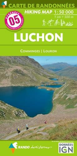
The Luchon region of the French Pyrenees, around St.Gaudens, the Louron Valley and Bagnรจres-de-Luchon, on a contoured and GPS compatible map at 1:50,000 from Rando Editions with topographic base provided by the IGN, highlighting local and long-distance hiking trails, cycle and mountain bike routes, etc. Topography is vividly presented by contours at 20m intervals enhanced by shading and graphic relief, plus colouring for woodlands and brushwood. An overprint highlights waymarked local and long-distance trails, including the course of the GR10, as well as other hiking paths, indicating difficult sections and traverses across ice. The map also highlights recommended mountain biking routes. A wide range of symbols presents different accommodation options (campsites, mountain refuges or lodges, gรฎtes d’etape), locations for various recreational pursuits (mountain biking, climbing, hand gliding, canoeing and rafting, etc), historical and cultural sites, tourist information offices, etc. On the Spanish side of the border, main hiking trails are highlighted but other recreational and tourist information is limited. The map has a 2km UTM grid and its map legend includes English. Current 5th edition of this title was published in 2008.To see the list of titles in this series please click on the series link.

Related Products:
 Pays Basque East Rando Editions 2
 Le Sentier Cathare – Queribus – Peyrepertuse Rando Editions 9
 Bรฉarn – Aspe – Ossau – Pyrenees National Park Rando Editions 3
 Bigorre – Cauterets – Gavarnie – Saint-Lary-Soulan – Pyrenees NP Rando Editions 4
 Haute-Ariรฉge Rando Editions 7
 Cerdagne-Capcir Rando Editions 8
 Couserans-Val d`Aran Rando Editions 6
 Collioure-Cadaquรฉs Rando Editions 11
 Pyrenees Rando Editions
 Kamnik and Savinja Alps Kartografija WATERPROOF Hiking Map
 Triglav Pocket Map
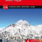
 Triglav Slovenian Alpine Club 25K Map
 Karavanke Mountains – Kep to Kosuta Kartografija WATERPROOF Hiking Map
 Triglav Kartografija WATERPROOF Hiking Map
 Bled Pocket Map
 Kerry County
 Cork County
 Clare County
 Mercantour & Alpi-Marittime Didier Richard 07
 Mont-Blanc – Annecy Didier Richard 02
 Jasper & Maligne Lake Gem Trek
 Ljubljana and Environs Kartografija Tourist Map
Galway County
Ljubljana and Environs Kartografija Tourist Map
Galway County
 Mayo and Sligo Xploreit Counties Map
 Primorska Kartografija Tourist Map
 Posavsko Hribovje Kartografija Tourist Map
 El Pont de Suert
 Baixa Ribagorรงa
 Kootenay National Park Gem Trek Map
La Seu d’Urgell – PN de l’Alt Pirineu
Vall de Nรบria ‘“ Ulldeter
Alt Cardener – el Port del Comte
Organyร -Boumort – Serra de Taรบs
Vall de la Llosa – el Baridร
Puigcerda Llavia la Tossa d`Alp
Oliana – del Rialb a la Ribera Salada
Montsec d’Ares – Congost de Mont-rebei
Kootenay National Park Gem Trek Map
La Seu d’Urgell – PN de l’Alt Pirineu
Vall de Nรบria ‘“ Ulldeter
Alt Cardener – el Port del Comte
Organyร -Boumort – Serra de Taรบs
Vall de la Llosa – el Baridร
Puigcerda Llavia la Tossa d`Alp
Oliana – del Rialb a la Ribera Salada
Montsec d’Ares – Congost de Mont-rebei
 Stajerska – Slovene Hills – Haloze – Boc Kartografija Tourist Map
Tremp – la Pobla de Segur – Serra de Boumort – Isona
Stajerska – Slovene Hills – Haloze – Boc Kartografija Tourist Map
Tremp – la Pobla de Segur – Serra de Boumort – Isona