Disclosure : This site contains affiliate links to products. We may receive a commission for purchases made through these links.
Lousios Anavasi 8.51
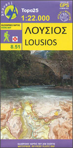
Lousios (Loussios) George in the northern part of the Peloponnese on a contoured and GPS compatible map at 1:22,000 from Anavasi, printed on light, waterproof and tear-resistant synthetic paper. Coverage extends from Dimitsana southwards to Karitena, and includes Stemnitsa with Klinitsa and the adjoining peaks. On one side is a topographic map of the area with contours at 20m intervals and bold altitude colouring. The map shows local footpaths and trails, including the route along the river gorge. Road network indicates dirt roads in poor condition, shows distances on main routes, and gives locations of petrol stations. Symbols highlight various places of interest, including churches, museums, archaeological sites, viewpoints, etc. The map has a 1km UTM grid, plus latitude and longitude cross-hairs at 1’ intervals. Map legend includes English.On the reverse is a simplified map, without contours and colouring, to show more clearly the area’s network of trails and roads. Many places are annotated with bilingual Greek/English descriptions.To see all the titles in this series please click on the series link.

Related Products:
 Mainalo – Artemisio – Lyrkeio – Farmakas – Ktenias Anavasi 8.5
 Mt Dikti – Mt Selena Anavasi 11.15
 Kythnos Anavasi 10.44
 Skyros Anavasi 10.14
 Karpathos – Saria Anavasi 10.50
 Paxos – Antipaxos Anavasi 9.2
 Iraklion – Rethymnon – Central Crete Anavasi 93
 Peloponnese Anavasi Road Atlas
 Athens Anavasi Pocket Map
 Chania – Gavdos Anavasi 94
 Milos – Kimolos – Polyvos Anavasi 10.45
 Lasithi – Eastern Crete Anavasi 92
 Chalki Anavasi 10.33
 Messinia Anavasi 17
 Attica – Boeotia Anavasi 10
 Mount Pelion – Mount Mavrovouni Anavasi 4.3/4.4
 Santorini – Thirasia Anavasi 10.24
 Sikinos Anavasi 10.29
 Northern Agrafa – Plastira Lake Anavasi 4.1
 Kea / Tzia Anavasi 10.41
 Mani Anavasi 8.4
 Paros – Antiparos Anavasi 10.23
 Greece: Anavasi 100K Touring Maps of Crete
 Evia / Euboea – Skyros Anavasi 04
 Fokidha Anavasi 07
 Tinos Anavasi 10.20
 Achaia Anavasi 13
 Mt Parnitha Anavasi 1.1
 Prespa – Vitsi – Voras Anavasi 6.2
 Cephalonia / Kefalonia – Ithaca Anavasi 9.3
 Peloponnese Anavasi Regional Map R2
 Slovenia Reise Know-How
 Alonisos – Northern Sporades Marine Park Anavasi 9.2
 Sifnos Anavasi 10.26
 Mykonos – Delos – Rheneia / Rineia Anavasi 10.42
 Spetses Anavasi 10.30
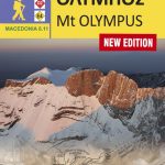 Mt Olympus Anavasi 6.11
 Cyclades – Argosaronic Anavasi Regional Map R1
 Exo Mani – Verga – Kardamyli – Trachila Anavasi 8.10