Disclosure : This site contains affiliate links to products. We may receive a commission for purchases made through these links.
London`s Lost Rivers
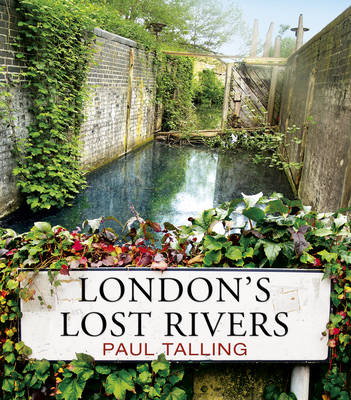
From the sources of the Fleet in Hampstead`s ponds to the mouth of the Effra in Vauxhall, via the meander of the Westbourne through `Knight`s Bridge` and the Tyburn`s curve along Marylebone Lane, “London`s Lost Rivers” unearths the hidden waterways that flow beneath the streets of the capital. Paul Talling investigates how these rivers shaped the city – forming borough boundaries and transport networks, fashionable spas and stagnant slums – and how they all eventually gave way to railways, roads and sewers. Armed with his camera, he traces their routes and reveals their often overlooked remains: riverside pubs on the Old Kent Road, healing wells in King`s Cross, `stink pipes` in Hammersmith and gurgling gutters on streets across the city. Packed with maps and over 100 colour photographs, “London`s Lost Rivers” uncovers the watery history of the city`s most famous sights, bringing to life the very different London that lies beneath our feet.

Related Products:
 London`s Lost Rivers: A Walker`s Guide: Volume 2
 London`s Lost Rivers: a Walker`s Guide
 Swimming to Heaven: the Lost Rivers of London
 The Lost City of London
 London`s Riverside Pubs: A Guide to the Best of London`s Riverside Watering Holes
 Lost In London: Adventures in the City`s Wild Outdoors
 The Vanished City: London`s Lost Neighbourhoods
 London`s Hidden Rivers: A Walker`s Guide to the Subterranean Waterways of London
 Underground London ‘“ Travels beneath the City Streets
 London`s Waterside Walks: 21 Walks Along the City`s Most Interesting Rivers, Canals & Docks
 London`s Lost Music Venues
 Unearthing London
 London Clay: Journeys in the Deep City
 A Historical Riverside London Pub Walk
 Lies Sleeping – The Seventh `Rivers of London` Novel
 Lost London in Colour
 The Lost Gallows: A London Mystery
 London`s Lost Battlefields
 Images of Lost London 1875-1945
 London`s Lost Power Stations and Gasworks
 This Other London: Adventures in the Overlooked City
 London: Global City of Commerce and Culture
 Thames Mudlarking: Searching for London`s Lost Treasures
 Rivers Of London
 Modern London: An illustrated tour of London`s cityscape from the 1920s to the present day
 What Abigail Did That Summer: A Rivers Of London Novella
 Alexandria Lost
 Walking the Streets of London
 The King`s City: London Under Charles II: A City That Transformed a Nation – And Created Modern Britain
 Pilgrim`s Guide To Sacred London, A
 Civil War London: A Military History of London Under Charles I and Oliver Cromwell
 London Graffiti and Street Art: Unique Artwork from London`s Streets
 The Subterranean Railway: How the London Underground was Built & How it Changed the City Forever
 Whispers Under Ground – The Third `Rivers of London` Novel
 Exploration Fawcett: Journey to the Lost City of Z
 False Value – The Eighth `Rivers of London` Novel
 Great Stink of London
 A History of London Through Beer Goggles
 Viking London
 London: The Concise Biography