Disclosure : This site contains affiliate links to products. We may receive a commission for purchases made through these links.
London Borch
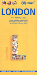
London on a laminated, so waterproof and tear-resistant map Borch combining several panels to provide coverage of the city and its environs for visitors, including prominent highlighting for London’s 30 best sights.On one side is a street plan with wider coverage than found on most tourist plans, extending from Holland Park and Earl’s Court to the Greenwich and the O2 Arena, and north/south from Regent’s Park and St Pancras International rail terminal to the southern bank of the Thames. An inset at a less detailed scale extends the plan south-west to include Kew Gardens and Richmond Park. Names of tube stations are conveniently annotated to show the lines, various places of interest and facilities are prominently highlighted, and the plan also indicates locations of selected hotels.On the reverse the West End and the City are shown in greater detail and clarity. Another panel shows the Greater London area, including road access to Heathrow, Gatwick and Stanstead Airports, Windsor, etc. All the plans and the road map are indexed. Also provided are more detailed plans with access to the three airports, a diagram of London’s Underground/Overground network, climate diagrams, plus an administrative map of UK.


