Disclosure : This site contains affiliate links to products. We may receive a commission for purchases made through these links.
London A-Z M25 / Main Road Wall Map
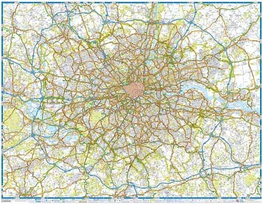
A wall map of the area within and adjoining to London’s orbital motorway, the M25, at 1:64,221 (approx. 1″ to 1 mile) from the Geographers` A-Z Map Company, paper version – size 117 x 91cm (46″ x 36″ approx). The map highlights primary routes and destinations, A and B roads, the capital’s Congestion Charge and Low Emission zones, plus indicates Red Routes – major roads on which vehicles are not permitted to stop; the prohibition extends to stopping for loading or unloading and to boarding or alighting from a vehicle (except for licensed taxis and the holders of blue badges).The map indicates full or limited interchanges and shows junction names and locations of single, multiple and variable speed cameras. Where appropriate, the direction of traffic flow is also marked. Railways and Underground lines outside central London are shown with station names. Important locations including airports, sport venues, etc, are highlighted. Also marked are 180ยฐ and 360ยฐ viewpoints. The map has the lines of British National Grid. Current edition of this title was published in 2012.

Related Products:
 London A-Z M25 / Main Road Map
 London: A-Z Street Atlases and Maps
 London A-Z Premier Map
 London A-Z Premier Map WATERPROOF
 London A-Z Mini Street Atlas PAPERBACK
 London Premier A-Z Wall Map PAPER
 Mongolia Road Edition Wall Map
 Libya Road Edition Wall Map
 Algeria Road Edition Wall Map
 India Road Edition Wall Map
 Central Asia Road Edition Wall Map
 London`s Green Belt Wall Map
 Silk Road Countries Wall Map
 Great Britain: AA Regional Road Maps
Italy F&B Great Road Atlas SPIRAL-BOUND
Great Britain: AA Regional Road Maps
Italy F&B Great Road Atlas SPIRAL-BOUND
 Stanford`s Map of the County of London (1888) – A3 Wall Map, Paper
Stanford`s Map of the County of London (1888) – A3 Wall Map, Canvas
Stanford`s Map of the County of London (1888) – A2 Wall Map, Paper
Stanford`s Map of the County of London (1888) – A2 Wall Map, Canvas
Stanford`s Map of the County of London (1888) – A1 Wall Map, Canvas
Stanford`s Map of the County of London (1888) – A3 Wall Map, Paper
Stanford`s Map of the County of London (1888) – A3 Wall Map, Canvas
Stanford`s Map of the County of London (1888) – A2 Wall Map, Paper
Stanford`s Map of the County of London (1888) – A2 Wall Map, Canvas
Stanford`s Map of the County of London (1888) – A1 Wall Map, Canvas
 50 Miles Around London A-Z Map
 Alpine Roads K+F Road Map
 London: Philip`s Street Atlases
 Caucasus Road Edition Wall Map
Stanford`s Map of the County of London (1888) – A1 Wall Map, Paper – Print on Demand
Caucasus Road Edition Wall Map
Stanford`s Map of the County of London (1888) – A1 Wall Map, Paper – Print on Demand
 Britain & Ireland Philip`s Big Road Atlas 2017
Catalonia ICC Road Atlas
Britain & Ireland Philip`s Big Road Atlas 2017
Catalonia ICC Road Atlas
 London: Braun and Hogenberg`s Elizabethan London 1572 Wall Map
 Rail Guide 2019: Main Line Systems
 Germany K+F Road Map
 Britain & Ireland Philip`s Complete Road Atlas 2017 SPIRAL-BOUND
 Estonia Jana Seta Road Map
 Macedonia Road Map
 Germany South K+F Road Map
 China South Wall Map
 Austria F&B Road Map Set
 Europe K+F Political Wall Map LAMINATED
 Tibet Road Edition Wall Map
 South Africa Giant Road Map