Disclosure : This site contains affiliate links to products. We may receive a commission for purchases made through these links.
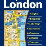
London A-Z Handy Map
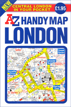
London: Central London Handy Map from A-Z publishers is an indexed mini-pocket sized street plan of the centre of London, ideal for visitors and containing a variety of tourist relevant information. At a scale of 1:11,520 / 5.5″ to a mile, the map also contains an enlargement of the West End / Soho areas of the capital at a scale of 1:8,562.Detailed transport information is provided on the main London map (which extends roughly from Spitalfields in the East to Kensington in the West, and from St Pancras in the North to Vauxhall in the South – with coverage of corner peripheries compromised by the inclusion of feature boxes). Street mapping signifies buildings open to the public and those of particular interest, as well as notable shops. The map is at pains to indicate the locations of hotels, theatres and cinemas, whilst also showing the visitor where to find tourist information centres and toilets. Transport maps – a tube plan and a plan of central London’s bus routes which contains indexed details of Transport for London and main Overground station locations – are provided. The map features a detailed list of the top places to visit in London. An indexed list on the reverse of the sheet shows the map references for an array of tourist and cultural attractions as well as cinemas, theatres, opera houses and music venues. Separate text is provided on the topics of tourist information, transport information and shopping.

Related Products:
 The Handy London Bensons Map & Guide
 Discovering London Collins Illustrated Map
 London Collins Pocket Map
 London Michelin Citymap
 London NGS City Destination Map
 London Bensons MapGuides Street Map
 London A-Z Visitor`s Atlas & Guide
 Linz F&B Tourist Street Plan
 Central London A-Z Map
 Grand Union Canal: Milton Keynes to London, with the London & East London Rings Heron Map
 Hollywood CA Global Graphics detailed Street Map
 London A-Z Street Atlas
 London Borch
 Sydney Suburbs & City Centre UBD Gregory`s 218
 London Collins Handy Street Map
 London A-Z Map & Walks
 London A-Z Big Street Atlas
 Greater London Collins Street Atlas
 London A-Z Visitors` Map
 Bangkok Handy Atlas
 Map of London Bensons MapGuides
 Melbourne UBD Gregory`s City Pocket 360
 Melbourne Suburbs & City Centre UBD Gregory`s 318
 London Guy Fox Children`s Map
 Kyoto & Japan West ITMB
 Moscow Street Atlas
 London Mini Map Bensons MapGuides
 Scotland Collins Handy Road Atlas
 London: Philip`s Street Atlases
 Singapore Periplus Travel Map
 London Children`s Map (FRENCH LANGUAGE)
 London Michelin City Map
 Sydney & North Sydney UBD Gregory`s City Pocket 260
 London West End A-Z Mini Map
 Buenos Aires Borch
 Zรผrich Tourist Map
 Vancouver Borch
 London F&B City Pocket Map
 Salzburg F&B Tourist Street Plan
 Stockholm Tourist Map