Disclosure : This site contains affiliate links to products. We may receive a commission for purchases made through these links.
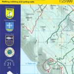
Loลกinj Island Croatian Mountain Rescue Service 25K Map
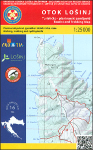
The island of Loลกinj on the Adriatic coast of Croatia on a double-sided, contoured and GPS compatible map at 1:25,000 from the Croatian Mountain Rescue Service, highlighting hiking paths, including trails on the southern part of Cres and on the nearby islands of Unije, Susak and Ilovik.Contours at 10m intervals enhanced by relief shading provide excellent presentation of the terrain, with markings for various topographic features. Waymarked hiking paths are prominently highlighted. Symbols indicate tourist accommodation, including campsites, restaurants, beaches, climbing sites, petrol stations, etc. The map has a 1km UTM grid, plus latitude and longitude lines at 1’ intervals. Map legend includes English.This map is printed on demand, and if it`s out of stock it could take 3 – 4 months waiting time.To see the list of titles in this series please click on the series link.

Related Products:
 Mljet Island Croatian Mountain Rescue Service 20K Map
 Paลกman Island Croatian Mountain Rescue Service 25K Map
 Istria: Cicarija Plateau Croatian Mountain Rescue Service 25K Map
 Paklenica National Park Croatian Mountain Rescue Service 25K Map
 Dugi, Iลพ & Sestrunj Islands Croatian Mountain Rescue Service 25K Map
 Ugljan, Rivanj & Sestrunj Islands Croatian Mountain Rescue Service 25K Map
 Biokovo Mountains Croatian Mountain Rescue Service 25K Map
 Kameลกnica Mountain Croatian Mountain Rescue Service 25K Map
 Rab Island Croatian Mountain Rescue Service 25K Map
 Croatia: Mountain Rescue Service Recreational Maps
 Dalmatian Coast North – Krk ‘“ Cres ‘“ Loลกinj ‘“ Rab ‘“ Pag – Zadar Kompass 2901
 Easter Island / Rapa Nui
 Marina Baixa – Serra d`Aitana Editorial Piolet
 Picos de Europa National Park 3-Map and Guide Set CNIG ENGLISH
 Serra de Bernia – Marina Alta Editorial Piolet
 Picos de Europa National Park 3-Map and Guide Set CNIG SPANISH
 Sierra de Guadarrama National Park 4-Map and Guide Set CNIG
 Chefchaouen – Chauen
 Mรกtra Cartographia Tourist Map 14
 Zselic Cartographia Tourist Map 17
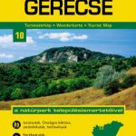 Gerecse Cartographia Tourist Map 10
 Borzsony Cartographia Tourist Map 5
 Bรผkk Cartographia Tourist Map 29
 Vรฉrtes Cartographia Tourist Map 20
 Gemenc – Szekszard-Hills Tourist Map
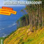 Wolin Island – Wolinski National Park ExpressMap Tourist Map
 Buda Hills Cartographia Tourist Map 6
 Orsรฉg – Gรถcsej – Kemeneshat Cartographia Tourist Map 21
 Koszeg Hills Cartographia Tourist Map 13
 Mecsek – Villรกny Mountains Cartographia Tourist Map 15
 Vall de Lord – Port del Comte Editorial Alpina
 Cabaรฑeros National Park CNIG Map-Guide SPANISH
 Cserhat – Karancs – Medves Cartographia Tourist Map 8
 Zemplen Hills South Cartographia Tourist Map 23
Bachimala – Valles de Chistau y Bielsa Editorial Alpina
Zemplen Hills South Cartographia Tourist Map 23
Bachimala – Valles de Chistau y Bielsa Editorial Alpina
 Gรถmรถr – Tornai-Karszt – Cserehรกt Cartographia Tourist Map 1
 Zemplen Hills North Cartographia Tourist Map 22
Pilis – Visegrad Hills Cartographia Tourist Map 16
Zemplen Hills North Cartographia Tourist Map 22
Pilis – Visegrad Hills Cartographia Tourist Map 16
 Alta Garrotxa – Comanegra – Bassegoda – el Mont Editorial Alpina
 Lake Balaton Cartographia Tourist Map 4