Disclosure : This site contains affiliate links to products. We may receive a commission for purchases made through these links.
Lisnaskea, Newtownbutler and The Upper Erne 1900
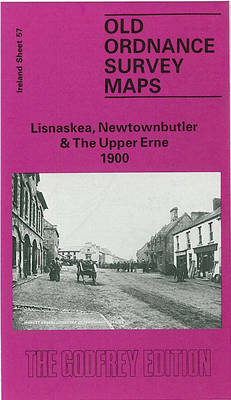
Lisnaskea, Newtownbutler and the Upper Erne in 1900 in the Alan Godfrey Edition of historical Ordnance Survey mapping at one inch to one mile. The map covers much of southern Co. Fermanagh, with small sections of Counties Cavan and Monaghan. Most of Upper Lough Erne is covered and coverage stretches from Kinawley eastward to Munnilly House, and from Derryharney southward to Bawnboy. The main settlements are Lisnaskea and Newtown Butler. Other features include stretches of the Ulster Canal, the Great Northern Railway, and the GNR Cavan and Clones Branch; Crom Castle, Lanesborough Lodge. On the reverse we are town plans for Lisnaskea and Newtown Butler, at a scale of 18 inches to the mile and presenting them in detail. The map for Lisnaskea includes Main Street with houses/shops neatly shown either side, churches, workhouse, Town Hall, Balfour Castle, creamer, with extracts from the town directory. The map for Newtown Butler includes Court House, railway with station, St Congall`s church, Lurganboy Cottage, etc.*About Alan Godfrey Editions of OS 1″ to 1 mile maps of Ireland:*The maps provide an invaluable overview of a wider area, typically 18 x 12 miles (29 x 19kms approx.), and offer historical mapping for small villages not covered by the more detailed series for which the Godfrey Editions are better known. All the maps include historical notes and all, unless indicated in the individual description, also include a large scale map of a small town or village in the area.


