Disclosure : This site contains affiliate links to products. We may receive a commission for purchases made through these links.
Leytonstone & Leyton 1915 – 23.3
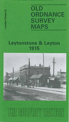
Leytonstone and Leyton in 1915 in a fascinating series of reproductions of old Ordnance Survey plans in the Alan Godfrey Editions, ideal for anyone interested in the history of their neighbourhood or family. Two versions for this area have been published, stretching from Manor Road and Lea Hall Road eastward to Poppleton Road and St John the Baptist`s church; and from Grove Road southward to Grove Green Road. Features on the 1915 map include a stretch of the MR Tottenham & Forest Gate railway including Leyton station, Leyton cricket ground, tramways, Kinematagraph studio, Knotts Green, West Ham Union Infirmary, a short stretch of the GER Epping line including Leytonstone station, Forest House and the fringe of Epping Forest. Churches and streets include St John the Baptist`s High Road, St Catherine`s, St Stephen`s Grove Road, Hainault Road, Hoe Street, High Road, Peterborough Road, etc.About the Alan Godfrey Editions of the 25″ OS Series:Selected towns in Great Britain and Ireland are covered by maps showing the extent of urban development in the last decades of the 19th and early 20th century. The plans have been taken from the Ordnance Survey mapping and reprinted at about 15 inches to one mile (1:4,340). On the reverse most maps have historical notes and many also include extracts from contemporary directories. Most maps cover about one mile (1.6kms) north/south, one and a half miles (2.4kms) across; adjoining sheets can be combined to provide wider coverage.FOR MORE INFORMATION AND A COMPLETE LIST OF ALL AVAILABLE TITLES PLEASE CLICK ON THE SERIES LINK.

Related Products:
 Leytonstone 1893 – 23.2
 Leyton 1914
Leyton 1863-1867
Leyton 1914
Leyton 1863-1867
 Leytonstone & Leyton 1940 – 23.4
Theydon Bois 1915
Leytonstone & Leyton 1940 – 23.4
Theydon Bois 1915
 Highams Park and Hale End 1915 – 78.01
Wanstead 1915 – 24.3
Highams Park and Hale End 1915 – 78.01
Wanstead 1915 – 24.3
 Goodmayes and Seven Kings 1915
 Manchester South-East 1915
Hornchurch 1915 – 79.15
Manchester South-East 1915
Hornchurch 1915 – 79.15
 Hampstead 1915 – 27.3
Wanstead Flats 1893
Hampstead 1915 – 27.3
Wanstead Flats 1893
 Kew, Gunnersbury & Old Brentford 1913
East Ham & Barking 1915 – 44.3
Kew, Gunnersbury & Old Brentford 1913
East Ham & Barking 1915 – 44.3
 Highgate 1869 – 19.1
 Highgate 1894 – 19.2
 Highgate 1936 – 19.4
 Highgate 1913 – 19.3
 Old Trafford 1915
Chipping Ongar 1915
Old Trafford 1915
Chipping Ongar 1915
 Peckham 1894 – 103.2
 Peckham 1914 – 103.3
Peckham 1871 – 103.1
Whetstone 1897
Brightlingsea 1895
Peckham 1914 – 103.3
Peckham 1871 – 103.1
Whetstone 1897
Brightlingsea 1895
 Cheetham & Higher Broughton 1915 – 104.02b
Tottenham 1936 – 13.4
Cheetham & Higher Broughton 1915 – 104.02b
Tottenham 1936 – 13.4
 Tottenham (North) 1936 – 8b
 Lewisham 1914 – 119.3
 Lewisham 1863-67 – 119.1
Manchester North West and Central Salford 1915
Lewisham 1863-67 – 119.1
Manchester North West and Central Salford 1915
 Wavertree and Broad Green 1905
Wylde Green 1913
Wavertree and Broad Green 1905
Wylde Green 1913
 Southall Green 1935
Stratford 1867 – 42.1
Southall Green 1935
Stratford 1867 – 42.1
 Stratford 1914 – 42.3
 Harborne 1901
 Ealing 1934
 Ealing 1894
Stanley 1915
Ealing 1894
Stanley 1915