Disclosure : This site contains affiliate links to products. We may receive a commission for purchases made through these links.
Lesotho InfoMap
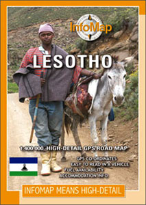
Lesotho on a road map from South African publishers International Motoring Productions with GPS waypoints for selected small towns or settlements, road junctions and recommended accommodation or campsites.The map, one of a series of similar maps covering countries and selected regions of southern Africa, has rather simple cartography with somewhat basic elevation tinting, spot heights, rivers and lakes and names of main peaks and mountain ranges. Main protected areas are highlighted.Roads are classified as main, tarred, gravel 2WD or 4WD tracks and show driving distances on selected routes and locations of fuel stations. Border crossings to South Africa are shown with opening times. Local airfields are marked and symbols indicate various places of interest and accommodation.The map has lists of GPS waypoints for selected villages and road junctions. GPS coordinates are also provided for recommended accommodation, some with contact details and symbols indicating what facilities can be found there.An enlargement shows the Lekhatje/Jobo Mountain area, there is also a basic plan of Maseru with accommodation, facilities, etc. Also included are notes on travelling in the country, customs regulations, etc.

Related Products:
 Zambia InfoMap
 South Africa: InfoMap Touring Maps
 Namibia InfoMap
 Zimbabwe InfoMap
 Kaokoland – North Western Namibia InfoMap
 Swaziland
 Botswana InfoMap
 Lesotho Map Studio Adventure Map
 Cape West Coast – Cederberg & Tankwa Karoo InfoMap
 Mozambique and Malawi
 Angola InfoMap
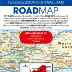
 South Africa – Lesotho – Swaziland ITMB
 Damaraland
 South Africa InfoMap
 Kruger National Park
 South Africa – Lesotho & Swaziland Map Studio
 Transkei Wild Coast
 Richtersveld National Park and Northern Namaqualand
 Drakensberg and the Eastern Free State
 Megaliesberg – Pilanesberg and the Waterberg
 Namibia Map Studio Adventure Map
 South Africa Map Studio Road Atlas A4 PAPERBACK
 Zimbabwe Map Studio Adventure Map
Garden Route & Route 62 Map Studio
Zimbabwe Map Studio Adventure Map
Garden Route & Route 62 Map Studio
 South Africa Giant Road Map
 Malawi Map Studio Adventure Map
 4×4 Routes Through Southern Africa
 The Rough Guide to South Africa, Lesotho and Swaziland
 Africa Map Studio Road Atlas
 Zambia Road Map
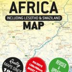
 Africa Southern ITMB
 Lonely Planet South Africa, Lesotho & Swaziland
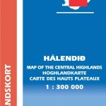 Iceland Central Highlands
 Iceland South West
 Iceland South East
 Western Australia Hema Road & 4WD Track Atlas A4 SPIRAL-BOUND
 Southern Norway South – Oslo – Stavanger – Bergen – Hardangervidda Cappelen Sectional Road Map
 Nordland and South Troms – Bronnoysund – Bodo – Narvik Cappelen Sectional Road Map
 Denmark South – Kolding – Copenhagen – Bornholm K+F Regional Road Map
 Cederberg Mountains Hiking Set (2-map set)