Disclosure : This site contains affiliate links to products. We may receive a commission for purchases made through these links.
Lefkada Anavasi 9.1
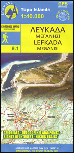
Lefkada / Lefkas in the Ionian Islands on light, a waterproof and tear-resistant, contoured and GPS compatible map at 1:40.000 from Anavasi, with on the reverse a street plan of the Lefkada Town, recommendations for hiking trails, general notes about the island, etc. Coverage includes the near-by island of Meganisi and part of the adjoining mainland.Landscape is vividly shown by contours at 20m with altitude colouring, hill shading and spot heights, plus graphics to show various types of vegetation: woodlands, olive groves, vineyards, etc. The map indicates dirt roads in poor condition and difficult tracks, with distances marked on many local routes, plus locations of petrol stations. Country paths distinguish between wide and well defined or narrow and/or poorly defined routes. Symbols highlight campsites, hostels and places of interest. All place names are in both Greek and Latin alphabets. The map has a 1km UTM grid plus latitude/longitude margin ticks and crosshairs at 1’. The index of settlements is on the reverse.The reverse side also includes separate maps and brief descriptions of three recommended walks, a street plan of Lefkada Town indicating various facilities, plus general notes about the island. Map legend and all the text include English.To see which other Greek islands are covered by maps from Anavasi, please click on the series link.

Related Products:
 Syros Anavasi 10.22
 Chios – Psara – Inouses Anavasi 10.31
 Amorgos Anavasi 10.27
 Mykonos – Delos – Rheneia / Rineia Anavasi 10.42
 Skiathos Anavasi 10.11
 Spetses Anavasi 10.30
 Kalymnos – Telendos & Pserimos Anavasi 10.32
 Serifos Anavasi 10.25
 Rhodes & Symi Anavasi 10.38
 Skyros Anavasi 10.14
 Sifnos Anavasi 10.26
 Kythnos Anavasi 10.44
 Andros Anavasi 10.21
 Lefkada Terrain Editions 351
 Corfu – Othoni – Erikouse – Mathraki Anavasi 9.4
 Naxos & Small Cyclades Anavasi 10.28
 Alonisos – Northern Sporades Marine Park Anavasi 9.2
 Hydra Anavasi 10.40
 Anafi Anavasi 10.47
 Milos – Kimolos – Polyvos Anavasi 10.45
 Kea / Tzia Anavasi 10.41
 Greece: Anavasi Maps of Greek Islands
 Chalki Anavasi 10.33
 Sikinos Anavasi 10.29
 Lefkada – Paxos and Antipaxos Tour and Trail Maps
 Tinos Anavasi 10.20
 Cephalonia / Kefalonia – Ithaca Anavasi 9.3
 Greece: Anavasi Hiking Maps of Crete
 Spetses Terrain Editions 360
 Karpathos – Saria Anavasi 10.50
 Prespa – Vitsi – Voras Anavasi 6.2
 Northern Agrafa – Plastira Lake Anavasi 4.1
 Santorini – Thirasia Anavasi 10.24
 Paros – Antiparos Anavasi 10.23
 Cyclades – Argosaronic Anavasi Regional Map R1
 Greece Anavasi Road Map
 Zakynthos Terrain Editions 355
 Lasithi – Eastern Crete Anavasi 92
 Peloponnese Anavasi Road Atlas