Disclosure : This site contains affiliate links to products. We may receive a commission for purchases made through these links.
Le Grigne
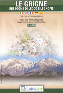
Le Grigne group along the eastern side of Lake Como on a detailed topographic, GPS compatible walking map at 1:35,000 from Litografia Artistica Cartografica (LAC) with very clear presentation of the terrain and hiking routes. The map has contours at 50m intervals enhanced by shading and graphic relief to show exposed rocky areas, plus numerous spot heights. Colouring and/or graphic show different types of woodlands, heath, orchards, vineyards, etc. The map highlights waymarked hiking routes, indicating the ‘Via Ferrata” sections, and locations of mountain refuges. Road network indicates routes closed to motorized traffic. Railway lines and ski lifts are also included. The map has a UTM grid. Map legend includes English.

Related Products:
 Val Brembana – Valsassina – Le Grigne: Lecco – Bergamo 50K IGC Map No. 22
 Alpe di San Benedetto 21
 Alpe della Luna 17
Monte Fumaiolo – Monte Comero 18
Monte Carpegna – Sasso di Simone
Alpe della Luna 17
Monte Fumaiolo – Monte Comero 18
Monte Carpegna – Sasso di Simone
 Colline di Forlรญ
Alta Val Tiberina
Alta Val Marecchia
Bagno di Romagna Monti Editore 19
Colline di Forlรญ
Alta Val Tiberina
Alta Val Marecchia
Bagno di Romagna Monti Editore 19
 Alta Valle del Lamone 22
Alta Valle del Santerno 23
Italy: IGA 25K Hiking Maps of Central Italy
Alta Valle del Lamone 22
Alta Valle del Santerno 23
Italy: IGA 25K Hiking Maps of Central Italy
 Foreste Casentinesi NP Monti Editore 20
Riviera Cesenate – San Marino
Foreste Casentinesi NP Monti Editore 20
Riviera Cesenate – San Marino
 Majella 6-Map Set
Italy: IGA 50K Hiking Maps of Central Italy
Appennino Tosco-Romagnolo East
Majella 6-Map Set
Italy: IGA 50K Hiking Maps of Central Italy
Appennino Tosco-Romagnolo East
 Luchon Rando Editions 5
 Pays Basque East Rando Editions 2
 Gavarnie-Ordesa Rando Editions 12
Colline di Rimini
Alta Valle del Metauro: Valle del Candigliano, Monte Nerone, Monte Catria
Gavarnie-Ordesa Rando Editions 12
Colline di Rimini
Alta Valle del Metauro: Valle del Candigliano, Monte Nerone, Monte Catria
 Bรฉarn – Aspe – Ossau – Pyrenees National Park Rando Editions 3
 Valsavarenche – Gran Paradiso L`Escursionista Editore 9
 Pays Basque West Rando Editions 1
 Parco di Veio
Parco d`Abruzzo
Parco di Veio
Parco d`Abruzzo
 Triglav Slovenian Alpine Club 25K Map
 Valpelline – Saint-Barthรฉlemy L`Escursionista Editore 6
 Monte Bianco / Mt Blanc – Courmayeur L`Escursionista Editore 1
 Bernina – Valmalenco – Sondrio L`Escursionista Editore 21
 Valgrisenche – Val di Rhemes – Valsavarenche L`Escursionista Editore 3
 Val di Champorcher – Mont Avic L`Escursionista Editore 11
Valle di Cogne – Gran Paradiso L`Escursionista Editore 10
Val di Champorcher – Mont Avic L`Escursionista Editore 11
Valle di Cogne – Gran Paradiso L`Escursionista Editore 10
 Bigorre – Cauterets – Gavarnie – Saint-Lary-Soulan – Pyrenees NP Rando Editions 4
Basse valli d`Ayas e del Lys L`Escursionista Editore 12
Bigorre – Cauterets – Gavarnie – Saint-Lary-Soulan – Pyrenees NP Rando Editions 4
Basse valli d`Ayas e del Lys L`Escursionista Editore 12
 Canigou-Garrotxa Rando Editions 10
Alte Valli di Lanzo – Val Grande – Val d`Ala – Val di Viu L`Escursionista Editore 17
Canigou-Garrotxa Rando Editions 10
Alte Valli di Lanzo – Val Grande – Val d`Ala – Val di Viu L`Escursionista Editore 17
 Corsica North Didier Richard 08
 Conca di Aosta – Mont Emilius – Mont Fallere L`Escursionista Editore 4