Disclosure : This site contains affiliate links to products. We may receive a commission for purchases made through these links.
L’ile de la Reunion GRs R1/R2/R3
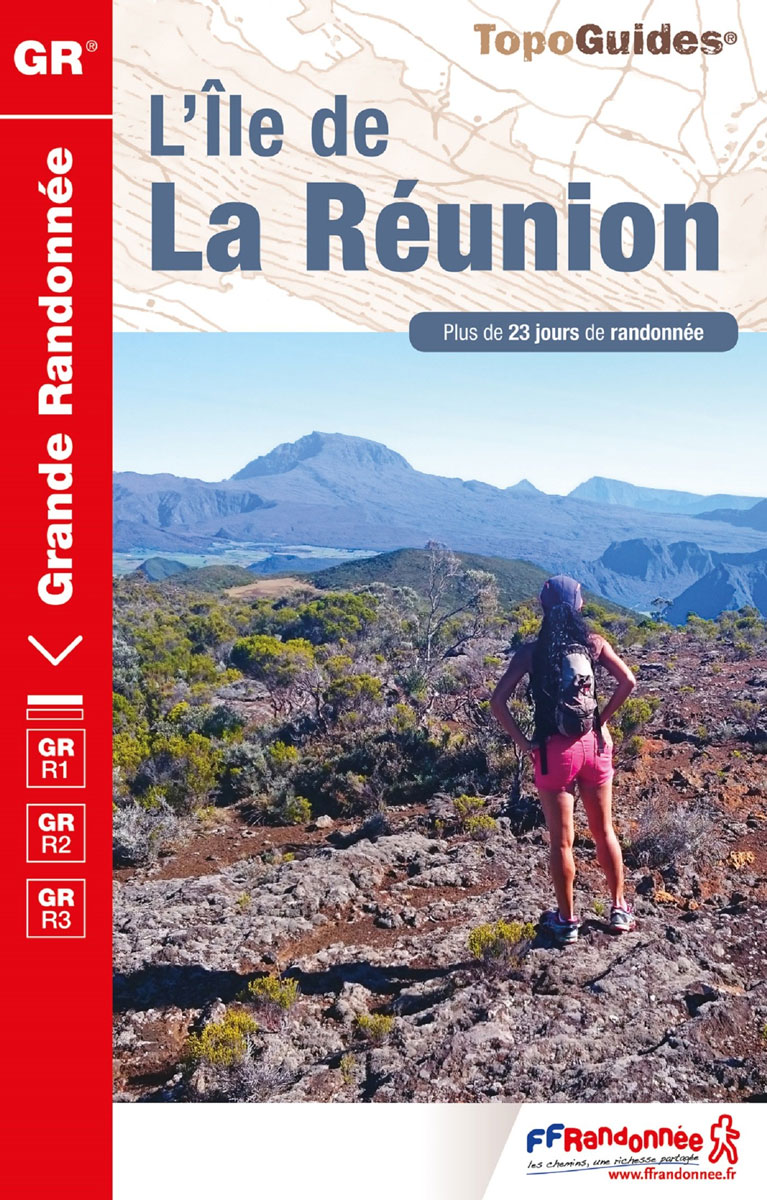
L’รฎle de L Rรฉunion. a French language topoguide from the Fรฉdรฉration Franรงaise de la Randonnรฉe Pรฉdestre as part of their extensive series of similar walking guides to France and its overseas departments. The guide covers three long-distance footpaths: GR R1 – Tour du Piton des Neiges, GR R2 from Basse-Vallรฉe to St Denis crossing the island, and GR R3 – Tour de Mafate. Colour extracts from the topographic survey of Reunion at 1:25,000 are overprinted with the routes. The descriptions of the routes are divided into short sections according to the difficulty of the terrain, and are always placed next to the maps for easy reference. The text is in French, but a large amount of information is conveyed by symbols. A list of all the main points along the routes indicates what facilities can be found there: public transport, food shops, accommodation etc. The guide also includes lists with contact addresses for various types of accommodation along the three routes, as well as for airlines, car hire, tourist offices, etc. A separate section, with beautiful drawings, is devoted to Reunion’s flora and fauna. Also included are notes on the island’s history, climate etc. The guide is illustrated with numerous photos. Current edition of this title was published in May 2014.

Related Products:
 Reunion IGN 84974
 Mauritius, Rodrigues and Reunion Bradt Guide
 Reunion – Saint-Leu – l`Etang Sale – PN de la Reunion IGN 4404RT
 Reunion – Saint-Paul le Port – PN de la Reunion IGN 4401RT
 Reunion – Piton de la Fournaise – PN de la Reunion IGN 4406RT
 Reunion – Saint-Pierre – Cirque de Cilaos – PN de la Reunion IGN 4405RT
 Reunion – Saint-Denis – Cirque de Mafate et de Salazie – PN de la Reunion IGN 4402RT
 Reunion – Saint-Pierre – Cirque de Cilaos – PN de la Reunion IGN WATERPROOF 4405RTR
 Reunion – Saint-Denis – Cirque de Mafate et de Salazie – PN de la Reunion IGN WATERPROOF 4402RTR
 Tour de Beaufortain
 Reunion – Saint-Benoit – Saint-Andre – PN de la Reunion IGN 4403RT
 GR40: Tour des Volcans du Velay FFRP Topo-guide No. 425
 Reunion: IGN 25K Topographic Survey Maps
 GR46/GRP: Au pays du George Sand FFRP Topo-guide No. 361
 Mauritius – Reunion – Rodrigues Reise Know-How
 GRP: Autour des Gorges de la Loire du Forez au Roannais FFRP Topo-guide No. 420
 Mauritius & Reunion ITMB
 Reunion F&B
 Lonely Planet Mauritius, Reunion & Seychelles
 Tour du Queyras GR58
Tour du Mont-Lozere et du Causse Mรฉjean GR6/GR68
Tour du Queyras GR58
Tour du Mont-Lozere et du Causse Mรฉjean GR6/GR68
 Hong Kong Marco Polo City Map
Tour des Monts d`Aubrac GRP/GR60/GR6
Hong Kong Marco Polo City Map
Tour des Monts d`Aubrac GRP/GR60/GR6
 GRP: Tours du Bassin minier FFRP Topo-guide No. 5962
Pyrรฉnรฉes Occidentales – Pays basque – Bรฉarn GR8/GR10
GRP: Tours du Bassin minier FFRP Topo-guide No. 5962
Pyrรฉnรฉes Occidentales – Pays basque – Bรฉarn GR8/GR10
 Le Chemin de Rรฉgordane – Chemin de Saint-Gilles GR700
Tour de l`Oisans et des Ecrins – Parc National des Ecrins GR54/GR541
Tour du Cotentin – Littorral de la Normandie GR223
Le Chemin de Rรฉgordane – Chemin de Saint-Gilles GR700
Tour de l`Oisans et des Ecrins – Parc National des Ecrins GR54/GR541
Tour du Cotentin – Littorral de la Normandie GR223
 GR145: The Via Francigena in Pas-de-Calais FFRP Topo-guide No. 1451
 Bicycle Island – Isle of Wight Heritage House Cycle Map
 Reunion Michelin Zoom 139
 Reunion in Barsaloi
 GR22: Chemin vers le Mont-Saint-Michel, Paris – Alenรงon – Mont St Michel FFRP Topo-guide No. 220
Tour du Larzac, Templier – Hospitalier – Entre causses et vallรฉes GR71C/GR71D
GR22: Chemin vers le Mont-Saint-Michel, Paris – Alenรงon – Mont St Michel FFRP Topo-guide No. 220
Tour du Larzac, Templier – Hospitalier – Entre causses et vallรฉes GR71C/GR71D
 The Essential Guide to London`s Best Food Shops
 GRP: Tours et Ronde du Canigรณ FFRP Topo-guide No. 6600
France: FFRP Topo-guides to Long-distance Footpaths
GRP: Tours et Ronde du Canigรณ FFRP Topo-guide No. 6600
France: FFRP Topo-guides to Long-distance Footpaths
 Menorca Walking Guide- 16 Day and 2 Multi-day Routes
 GR93/GR94 Tours dans les Hautes-Alpes FFRP Topo-guide No. 940
 GRP: Ariรจge-Pyrรฉnรฉes ‘“ Andorre – Catalogne FFRP Topo-guide No. 1098