Disclosure : This site contains affiliate links to products. We may receive a commission for purchases made through these links.
Kyoto & Japan West ITMB
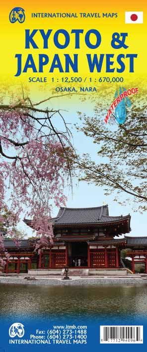
Kyoto on a detailed street plan at 1:12,500 from ITMB, with a road map of the Kyoto – Osaka – Nara area, plus a street plan of central Nara and, on the reverse, an indexed road map of western Japan at 1:670,000 and a street plan of central Osaka.On one side is a street plan of Kyoto highlighting places of interest including selected hotels, department stores, temples and shrines, etc. Metro stations show locations of individual entrances/exits. Main traffic routes are highlighted and one way streets are marked. As is normal on street plans of Japanese cities, only main streets are named and the plan shows names of districts and zones. The index lists streets, districts, zones, and temples/shrines. The plan is accompanied by a road map of the Kyoto – Osaka – Nara area.On the reverse is an indexed road map of central Japan at 1:670,000 extending from Tokyo westwards to Matsuyama on north-eastern Shikoku. The map shows the region’s road and rail networks and indicates various places of interest. An inset presents a street plan of central Osaka.

Related Products:
 Osaka & Western Japan ITMB
 Tokyo & Central Japan ITMB
 Japan ITMB
 Japan South ITMB Railway & Road Map
 Japan West & Central Railway & Road ITMB
 Japan Railway & Road ITMB Travel Atlas
 Japan North & Hokkaido ITMB
 Getting Around Kyoto and Nara
 Tuttle Kyoto and Nara Guide + Map: Your Guide to Kyoto`s Best Sights for Every Budget
 Sao Paulo & Brazil South Coast ITMB
 Japan Bilingual Atlas
 San Diego & USA South West Border ITMB
 Helsinki & Southern Finland ITMB
 Jakarta ITMB
 Zurich & Switzerland NW ITMB
 Moscow ITMB
 Philadelphia & Mid-Atlantic States ITMB
 New York City Borch
 Singapore & Malay Peninsula ITMB
 Kyoto City of Zen: Visiting the Heritage Sites of Japan`s Ancient Capital
 Lima & Central Peru ITMB
 Autumn Colors Of Kyoto
 Lonely Planet Pocket Kyoto & Osaka
 Kyoto – 29 Walks in Japan`s Ancient Capital
 Orlando & Central Florida ITMB
 Cool Japan: A Guide to Tokyo, Kyoto, Tohoku and Japanese Culture Past and Present
 Brisbane & Queensland ITMB
 Toronto & Southern Ontario ITMB
 Brisbane UBD Gregory`s City Pocket 460
 Manhattan & New York State ITMB
 Iran & Tehran ITMB
 Bangkok & Thailand South ITMB
 Bangladesh & India East ITMB
 Montreal & Southern Quebec ITMB
 Havana & Cuba Central ITMB
 Sydney & Australia East ITMB
 Chile ITMB
Japan: ITMB Regional Maps
Chile ITMB
Japan: ITMB Regional Maps
 Southern Ontario ITMB