Disclosure : This site contains affiliate links to products. We may receive a commission for purchases made through these links.
Kurzeme South Jana Seta Tourist Map
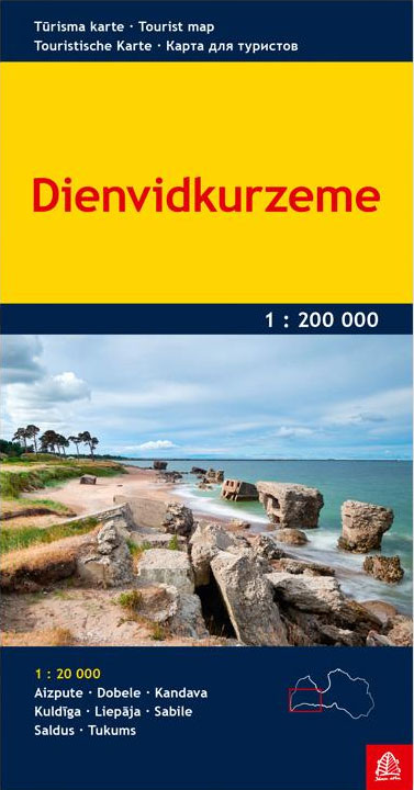
One of the titles in a series of detailed touring maps of Latvia with street plans of main towns. The maps, produced by Baltic States’ leading cartographic publisher, Riga based Jana Seta, show the country’s road network indicating unsurfaced roads and mark locations of petrol stations. Railway lines are shown with stations. Symbols highlight various types of accommodation including campsites, towns and other places of particular interest, border crossings, etc. National parks and protected areas are marked. Topographic information is limited to colouring for forested areas, plus rivers and other waterways and swamps. The maps have a latitude/longitude grid at intervals of 10’. Map legend includes EnglishEach map also includes plans of larger towns in the region, showing main streets and indicating locations of petrol stations, selected accommodation and places of interest.On the reverse there are photos and descriptions of all the regions’ main places of interest: historical monuments, local architecture, churches, natural features, etc. Although all the text is in Latvian only, the descriptions are cross-referenced to the map, providing a useful indicator of places worth visitingIn this title: street plans at 1:20,000 of eight biggest towns of Southern Kurzeme – Aizpute, Dobele, Kandava, Kuldiga, Liepajs, Sabile, Saldus and Tukums. Colour photos and descriptions show 56 main places of interest.

Related Products:
 Kurzeme North Jana Seta Tourist Map
 Latgale South Jana Seta Tourist Map
 Central Latvia Jana Seta Tourist Map
 Vidzeme North Jana Seta Tourist Map
 Vidzeme East – Latgale North Jana Seta Tourist Map
 Latvia: Jana Seta 200K Regional Touring Maps
 Lithuania: Jana Seta 200K/250K Regional Touring Maps
 Latvia Jana Seta Compact Road Atlas
 Pรคrnu Jana Seta Street Plan WATERPROOF
 Latvia: Jana Seta 75K Maps of Environs of Main Towns
 Lithuania Jana Seta Compact Road Atlas
 Tartu Jana Seta Street Plan WATERPROOF
 Lithuania Jana Seta Road Atlas HARDBACK
 Latvia Jana Seta Road Atlas
 Tallinn Jana Seta Street Plan WATERPROOF
 Estonia Jana Seta Road Atlas
Latvia 500K Jana Seta Map
Estonia Jana Seta Road Atlas
Latvia 500K Jana Seta Map
 Latvia: Jana Seta 100K Adventure Road Atlases
 Saldus and its Vicinity Jana Seta Map
 Kuldiga and its Vicinity Jana Seta Map
 Valmieras and its Vicinity Jana Seta Map
 Ventspils and its Vicinity Jana Seta Map
 Talsi – Dundaga – Roja Districts Jana Seta Map
 Lithuania & Kaliningrad Jana Seta Road Map
 Latvia 700K Jana Seta Map
 Kaunas Jana Seta Street Plan WATERPROOF
 Vilnius Jana Seta Street Plan WATERPROOF
 Saaremaa – Hiiumaa Jana Seta Map
 Carpathians Kartografija Tourist Map ENGLISH
 Riga City Center Jana Seta Street Plan
 Estonia South-East Regio Map
 Riga and Vicinity Jana Seta Street Atlas
 Estonia South-West Regio Map
 Zemplen Hills South Cartographia Tourist Map 23
 Kaunas Jana Seta Street Plan
 Riga and its Vicinity Jana Seta Map
 Czech Republic 100K Tourist Road Atlas
 Baja California South State – La Paz
 Cesis – Pargauja – Priekuli – Rauna – Ligatne – Amata Jana Seta Map
 Jurmala Jana Seta Street Plan