Disclosure : This site contains affiliate links to products. We may receive a commission for purchases made through these links.
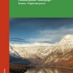
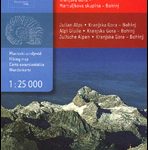
Krnsko Pogorje Slovenian Alpine Club 25k Map
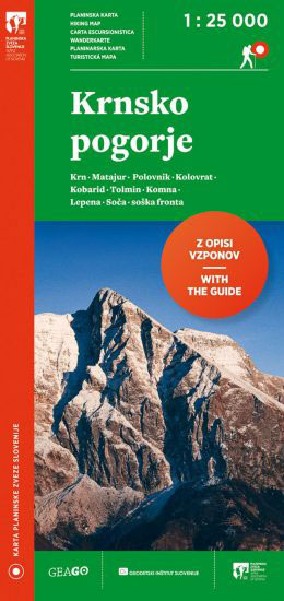
The mountain hiking map Krnsko pogorje – 1:25,000 is a new map by the Alpine Association of Slovenia, which offers an even more detailed presentation of the relevant area and is more clearly labelled than its predecessor. The map was collaboratively revised by the Geodetic Institute of Slovenia, the mapping company Geodetska druลพba and many individuals who are very familiar with the area presented on the map.Krnsko pogorje – 1:25,000 will come in handy for all who will explore the peaks, valleys and walls between the mountain Javorลกcek, the Lepena valley and the mountain hut Koca pri Triglavskih jezerih on the north, and the Matajur, Kolovrat and Tolmin on the south. The map`s east edge begins where the map Bohinj – 1 : 25,000 ends (a line between the hut Koca pri Triglavskih jezerih, Komna and the hut Koca na planini Razor, while the west edge is limited by villages ลฝaga and Borjana and Matajur mountain.The backside of the map contains the legend, as well as descriptions and contact information for mountain huts with associated QR codes linked to each hut`s website (links to www.en.pzs.si/koce.php). The information is complemented with textual descriptions and terrain surface maps of possible ascents to Krn, Matajur and Krasji vrh.The mountain hiking map Krnsko pogorje – 1:25,000 is in line with the new versions of Jalovec in Mangart, Grintovci, Bohinj, Stol and Triglav maps. Like in the mentioned maps, this map includes not only mountain trails, but also ski mountaineering routes, mountain huts, and a number of other useful information, such as parking lots, public transportation stops, lodging options, many natural and cultural attractions, climbing walls, and much more.

Related Products:
 Bohinj Slovenian Alpine Club 25K Map
 Stol Slovenian Alpine Club 25K
 Polhograjsko Hribovje Slovenian Alpine Club 25K Map
 Posavsko Hribovje East: Boc – Bohor Slovenian Alpine Club 50K Map
 Grintovci Slovenian Alpine Club 25K Map
 Triglav Slovenian Alpine Club 25K Map
 Ljubljana and Environs Slovenian Alpine Club 50K Map
 Storzic – Kosuta Slovenian Alpine Club 25K Map
 Jalovec and Mangart Slovenian Alpine Club 25k Map
 Slovenia: Alpine Club 50K and 25K Hiking Maps
 Bohinj Kartografija WATERPROOF Hiking Map
 Kamnik-Savinja Alps – Slovenian Carinthia
 Julian Alps of Slovenia: Mountain Walks and Short Treks
 The Slovenian Mountain Trail: Slovenska planinska pot
 Italy/France/Switzerland: L`Escursionista Editore Maps of High Alpine Tours
 The Rough Guide to Slovenia
Slovenia: Kartografija 40K Hiking and Cycling Sets
The Rough Guide to Slovenia
Slovenia: Kartografija 40K Hiking and Cycling Sets
 Mountain Biking in Slovenia: Julian Alps – Gorenjska and Soca Valley, South, Central and North East
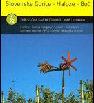 Stajerska – Slovene Hills – Haloze – Boc Kartografija Tourist Map
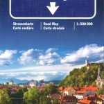 Slovenia – Croatia – Bosnia-Herzegovina K+F Road Map
 Julian Alps East – Bohinj – Triglav Tabacco 065
 Slovenia and the Slovenes
 Alpine Lakes Wilderness – Mt Baker-Snoqualmie and Okanogan-Wenatchee National Forests WA
 Munich Alpine Foreland Cycling Map
 Italy: Touring Club Italiano 400K Road Maps
 Berlitz Pocket Guide Slovenia (Travel Guide with Free Dictionary)
 Germany and Alpine Regions of Europe: Kompass Maps of Long-distance Footpaths
 Slovenia: Kartografija 75K Hiking Maps
 Tongariro Alpine Crossing
 Alpine Flowers – How to recognise over 230 Alpine Flowers
 Slovenia F&B Top 10 Tips
 Posavsko Hribovje Kartografija Tourist Map
 Triglav – Kranjska Gora – Bohinj
 Italy: Touring Club Italiano Regional Smart Maps
 Slovenia in your hands: All you need to know for visiting Slovenia in one guide
 Primorska Kartografija Tourist Map
 Leh, Zanskar and Nubra Valley
 Alpine Flowers Nature Guide
 Gangotri, Har-Ki-Dun & Mussoorie Area