Disclosure : This site contains affiliate links to products. We may receive a commission for purchases made through these links.
Knotty Ash and Old Swan 1906
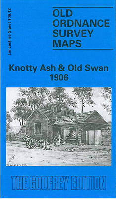
Knotty Ash and Old Swan in 1906 in a fascinating series of reproductions of old Ordnance Survey plans in the Alan Godfrey Editions, ideal for anyone interested in the history of their neighbourhood or family. The map covers the area of east Liverpool around Old Swan and Knotty Ash. Coverage stretches from Church Road Stanley eastward to St John`s Church Knotty Ash, and from Russian Drive southward to Oak Hill Park. Features include Knotty Ash, Old Swan Ward, Stoney Croft, Oakhill Park, Old Swan, Stanley (East), Highfield Infirmary, Old Swan Rope Works, Liverpool Cattle Market, tramways, St Oswald`s RC church, Derwent Square, Borax Works, Moss Farm, Fir Grove Farm, Cheshire Lines Railway with Knotty Ash & Stanley station, Hebrew Cemetery, Highfield House, Little Bongs, The Old Hall, etc. On the reverse are street directory entries for Green Lane, Leinster Road, Prescot Road, Russian Drive, St Oswald`s Street, Sandstone Road and Thomas Lane. About the Alan Godfrey Editions of the 25″ OS Series:Selected towns in Great Britain and Ireland are covered by maps showing the extent of urban development in the last decades of the 19th and early 20th century. The plans have been taken from the Ordnance Survey mapping and reprinted at about 15 inches to one mile (1:4,340). On the reverse most maps have historical notes and many also include extracts from contemporary directories. Most maps cover about one mile (1.6kms) north/south, one and a half miles (2.4kms) across; adjoining sheets can be combined to provide wider coverage.FOR MORE INFORMATION AND A COMPLETE LIST OF ALL AVAILABLE TITLES PLEASE CLICK ON THE SERIES LINK.

Related Products:
 Sedgley South-East with Swan Village and West Coseley 1901
 Whitstable East 1906
 Aintree 1906
 Central Leeds 1906 – 218.02b
 Whitstable (North) 1906 – 23.10
 Kirkdale 1906
 Rainhill 1906
Anfield 1908 – 106.07b
Redruth 1906
Rainhill 1906
Anfield 1908 – 106.07b
Redruth 1906
 Woolton 1904
Helston 1906
Woolton 1904
Helston 1906
 Bradford East 1906
 Walton on the Hill 1906
 Leeds East 1906
 Newton-le-Willows 1906
 Allerton 1905
 Holbeck & New Wortley 1906 – 218.05b
Penryn 1906
Holbeck & New Wortley 1906 – 218.05b
Penryn 1906
 Liverpool North 1906
 Central Liverpool 1906 – 106.14b
 Leeds South and South East 1906
South Yardley and Hay Mills 1903
Leeds South and South East 1906
South Yardley and Hay Mills 1903
 Liverpool Toxteth 1906
 Liverpool Princes Park 1905
Hindley Green 1906
Liverpool Princes Park 1905
Hindley Green 1906
 Meanwood and Far Headingley 1906
 Liverpool Edge Hill 1905
Willesden and Stonebridge Park 1936
Canterbury 1906 – 46.03
Lower Irlam and Cadishead 1926
Belfast (East) 1902 – 4.11
Liverpool Edge Hill 1905
Willesden and Stonebridge Park 1936
Canterbury 1906 – 46.03
Lower Irlam and Cadishead 1926
Belfast (East) 1902 – 4.11
 Garston 1905 – 113.12b
East Jarrow 1913
Garston 1905 – 113.12b
East Jarrow 1913
 Wavertree and Broad Green 1905
Swindon South-East 1899
Leeds Central and North East 1890
Wavertree and Broad Green 1905
Swindon South-East 1899
Leeds Central and North East 1890
 Warrington West 1905
 Croydon East: Coombe Park & Addiscombe Road 1895 – 158
Earlestown South 1906
Croydon East: Coombe Park & Addiscombe Road 1895 – 158
Earlestown South 1906
 Bootle 1907