Disclosure : This site contains affiliate links to products. We may receive a commission for purchases made through these links.
Kiev Kartografija Street Plan
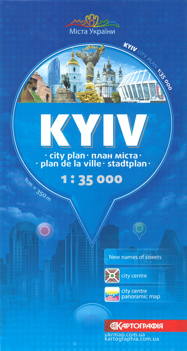
Street plan of Kiev from the locally based Kartografija in an English language edition presenting the whole city at 1:35,000, with a more detailed enlargement for the city centre, a 3-D pictorial plan of the central area including the Maidan Square, lists of sights, hotels, etc. All place names are in the Latin alphabet and map legend includes English.On one side is a plan of the city at 1:35,000. Main traffic arteries are highlighted and metro stations are prominently marked. Streets are annotated with selected house numbers for easier identification of addresses. Symbols show hotels (with names), shopping centres, various monuments and cultural institutions, places of worship, etc. The map has both present day administrative boundaries but also old historical names of various parts of the city. Insets present the city centre, from the Dnieper to the Solomianskyi railway terminal, in greater detail at 1:17,000, plus a map of the metro network.On the reverse Kiev’s historic heart is shown on a pictorial stylel street plan with all the buildings and monuments drawn in 3-D, with 25 best sights cross-reference to brief descriptions. Street index is supplemented by a list of hotels, cultural institutions, transport terminals and places of worship.IMPORTANT – PLEASE NOTE BEFORE ORDERING: supplies of all titles published in the Ukraine are irregular and we cannot guarantee a firm delivery time. When a title is out of stock, it may be advisable to choose an alternative publication.

Related Products:
 Kharkov Kartografija Street Plan
 Lviv Kartografija Street Plan
 Yalta Kartografija Street Plan
 Moscow Jana Seta Street Plan
 Sevastopol / Sebastopol – Balaklava Kartografija Street Plan
 Basel Pocket Street Plan
 Kiev F&B City Pocket
 St. Petersburg Jana Seta Street Plan
 Turin Global Map Street Plan
 Santiago de Chile Trekkingchile Street Plan
 Sofia Domino Street Plan
 Rome Global Map Street Plan
 Bishkek Street Plan
 Naples Global Map Street Plan
 Siena Global Map Street Plan
 Verona Global Map Street Plan
 Padua Global Map Street Plan
 Iasi Cartographia Street Plan
 Milan Global Map Street Plan
 Catania Global Map Street Plan
 Pisa Street Plan
 Genoa Global Map Street Plan
 Florence Global Map Street Plan
 Bergamo Global Map Street Plan
 Como Global Map Street Plan
Bari Global Map Street Plan
Como Global Map Street Plan
Bari Global Map Street Plan
 Vicenza Global Map Street Plan
Modena Global Map Street Plan
Cagliari Global Map Street Plan
Perugia Global Map Street Plan
Vicenza Global Map Street Plan
Modena Global Map Street Plan
Cagliari Global Map Street Plan
Perugia Global Map Street Plan
 Palermo Global Map Street Plan
 Bologna Global Map Street Plan
 Mantua Global Map Street Plan
 Parma Global Map Street Plan
 Pesaro – Urbino Global Map Street Plan
Ragusa Global Map Street Plan
Pesaro – Urbino Global Map Street Plan
Ragusa Global Map Street Plan
 Rimini Global Map Street Plan
 Sorrento Global Map Street Plan
 Ancona Global Map Street Plan