Disclosure : This site contains affiliate links to products. We may receive a commission for purchases made through these links.
Kavango Region Tourist Map
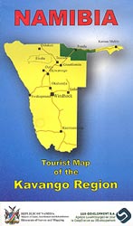
Kavango Region of north-eastern Namibia along the Okavango River on a double-sided map from the Namibian national survey organization combining four maps, information on climate and languages, tourist tips, etc.A general map at 1:500,000 provides an overview of the area. Roads and tracks indicate scenic sections and symbols mark locations of various facilities including tourist accommodation, fuel supplies, medical centres, etc. The base map derived from satellite imagery is coloured according to different types of vegetation. On the reverse three large panels provide extracts from Namibia’s topographic survey: the Khaudum Game Park at 1:250,000, plus Divundu & Mahango Park and the environs of Rundu at 1:50,000, again showing various facilities and sites of tourist interest. The maps have latitude and longitude grid lines for GPS navigation.The map also includes a distance table and driving tips, information about local population and its different languages, notes about malaria, climate charts, etc.

Related Products:
 Suwalki Region ExpressMap Tourist Map
Warsaw Environs ExpressMap Tourist Map
Krakรณw Environs ExpressMap Tourist Map
Klodzko Environs ExpressMap Tourist Map
Suwalki Region ExpressMap Tourist Map
Warsaw Environs ExpressMap Tourist Map
Krakรณw Environs ExpressMap Tourist Map
Klodzko Environs ExpressMap Tourist Map
 Brasov Region Tourist Map
 Bialystok Environs – Narwianski National Park ExpressMap Tourist Map
 Szczecin Environs ExpressMap Tourist Map
 Ljubljana and Environs Kartografija Tourist Map
Wroclaw Environs – Lower Silesia ExpressMap Tourist Map
Ljubljana and Environs Kartografija Tourist Map
Wroclaw Environs – Lower Silesia ExpressMap Tourist Map
 Namibia Map Studio Road Atlas
 Bydgoszcz and Torun Environs ExpressMap Tourist Map
Slowinski National Park ExpressMap Tourist Map
Nadmorski Regional Park – Hel Peninsula ExpressMap Tourist Map
Bydgoszcz and Torun Environs ExpressMap Tourist Map
Slowinski National Park ExpressMap Tourist Map
Nadmorski Regional Park – Hel Peninsula ExpressMap Tourist Map
 Gdansk – Sopot – Gdynia Environs ExpressMap Tourist Map
Mexico Road and Tourist Atlas
Gdansk – Sopot – Gdynia Environs ExpressMap Tourist Map
Mexico Road and Tourist Atlas
 Dublin City Centre Tourist Map
 Mรกtra Cartographia Tourist Map 14
 Zselic Cartographia Tourist Map 17
 Gerecse Cartographia Tourist Map 10
 Klodzko Region 2-Map Set
 Berlin and Environs Cycle Region Bikeline Map-Guide
 Iceland: Topographic Hiking and Tourist Maps
Gemenc – Szekszard-Hills Tourist Map
Iceland: Topographic Hiking and Tourist Maps
Gemenc – Szekszard-Hills Tourist Map
 Buda Hills Cartographia Tourist Map 6
 Borzsony Cartographia Tourist Map 5
 Bรผkk Cartographia Tourist Map 29
 Vรฉrtes Cartographia Tourist Map 20
 Orsรฉg – Gรถcsej – Kemeneshat Cartographia Tourist Map 21
 Mecsek – Villรกny Mountains Cartographia Tourist Map 15
 Zemplen Hills South Cartographia Tourist Map 23
 Lake Balaton Cartographia Tourist Map 4
 Botswana Tourist Map
 Biebrza National Park ExpressMap Tourist Map
Ojcowski National Park ExpressMap Tourist Map
Biebrza National Park ExpressMap Tourist Map
Ojcowski National Park ExpressMap Tourist Map
 Koszeg Hills Cartographia Tourist Map 13
 Gรถmรถr – Tornai-Karszt – Cserehรกt Cartographia Tourist Map 1
 Sognefjellet Nordeca Tourist Route 20008
 Valdresflye Nordeca Tourist Route 20006
Luxembourg: 20K Topographic Tourist Maps
Valdresflye Nordeca Tourist Route 20006
Luxembourg: 20K Topographic Tourist Maps
 Cserhat – Karancs – Medves Cartographia Tourist Map 8