Disclosure : This site contains affiliate links to products. We may receive a commission for purchases made through these links.
Karpathos – Saria Anavasi 10.50
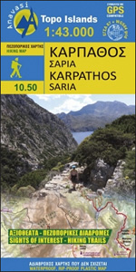
The Dodecanese island of Karpathos at 1:43,000 on a light, waterproof and tear-resistant, contoured and GPS compatible map from Anavasi with recommendations for 18 hiking trails, The map is double-sided, dividing Karpathos north/south with an overlap between the sides, and shows on an inset the nearby island of Saria. All place names are in both Greek and Latin alphabets.Topography is shown by contours at 20m intervals, enhanced by relief shading and altitude colouring. Road network indicates dirt roads in poor condition and shows locations of petrol stations and driving distances on main roads. The map distinguishes between cart tracks and well defined, narrow or faint footpaths. 17 hiking trails are highlighted on Karpathos, plus a route on Saria, and are cross-referenced to a list giving their distances. Symbols highlight various places of interest and facilities, including beaches, caves, archaeological remains, etc. The map has a 1km UTM grid plus latitude and longitude crosshairs at 1’. Map legend and all the text include English.To see which other islands are covered by maps from Anavasi, please click on the series link.


