Disclosure : This site contains affiliate links to products. We may receive a commission for purchases made through these links.
Jerusalem & Holy Land ITMB

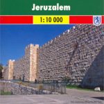
Waterproof and tear-resistant map from ITMB combining an indexed street plan of Jerusalem with a more detailed enlargement of its Old City, plus on the reverse a road map at 1:225,000 covering the Holy Land: northern Israel and the Palestinian Territories. On both the plans and the road map all place names are shown only in Latin alphabet. Within Jerusalem’s Old City sites of religious importance are given their alternative names.On one side is coverage of Jerusalem. The city with its outer districts is shown on an indexed plan at 1:10,000. On the eastern side of the Old City the plan includes the Mount of Olives and Mount Scopus; in the west it extends beyond the government district and the museum/university quarter but does not include Yad Vashem or Mount Herzl. Main traffic routes are highlighted and locations of petrol stations and car parks are marked. The Jerusalem light rail route is shown with stops. The plan highlights numerous places of interest and facilities, including selected hotels, embassies, museums and other cultural or educational institutions, places of worship, Israeli governmental buildings, etc. Accompanying the main plan are three additional panels: a large, very clear enlargement at 1:4,000 showing the Old City in much greater detail, including the Stations of the Cross on Via Dolorosa; a road map of the city’s environs including Bethlehem and Jericho, indicating the course of the Separation Barrier at the time of the map’s publication in 2014; plus a diagram of the existing and proposed light rail lines within the whole of Israel.The reverse side is covered by an indexed road map of most of Israel at 1:225,000, extending south to Rahat and the southern boundary of the West Bank (i.e. along the Dead Sea Masada and Ein Bokek are not included). The map has altitude colouring to show the topography, including the depression along the Jordan and the Dead Sea. National parks and other protected areas are marked. Road network indicates driving distances on main and selected secondary routes. Names of road junctions are not included. Railway lines marked, with a separate diagram of the network, and local airports are also shown. Towns with tourist accommodation are highlighted and symbols mark various other places of interest including campsites and youth hostels, archaeological sites, etc. Latitude and longitude lines are drawn at intervals of 10’. The map gives no indication which areas are now under the direct rule by the Palestinian authorities and the Separation Barrier is not marked.

Related Products:
 Tel Aviv-Jaffa & Central Israel ITMB
 Jerusalem Borch
 Old City of Jerusalem Map
 Holy Land – Israel – Palestine F&B Top 10 Tips
 Iran & Tehran ITMB
 Pakistan ITMB
 Belarus ITMB
 Quito & Central Ecuador ITMB
 Saudi Arabia & Kuwait ITMB
 Jordan & Syria ITMB
 Istanbul & Northwest Turkey ITMB
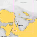
 Singapore & Malay Peninsula ITMB
 Munich & Bavaria ITMB
 Seattle & Northwest USA ITMB
 Zurich & Switzerland NW ITMB
 Easter Island & Santiago ITMB
 Kuwait & Kuwait City ITMB
 Tehran & Northern Iran ITMB
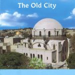 Jerusalem – the Old City
 Sydney & Australia East ITMB
 Hungary & Budapest ITMB
 Helsinki & Southern Finland ITMB
 Philadelphia & Mid-Atlantic States ITMB
 Paraguay – Bolivia South ITMB
 Israel Super Touring Map
 Jerusalem F&B City Pocket Map
 Jakarta ITMB
 Rome & Southern Italy ITMB
 Qatar and Doha City ITMB
 Jerusalem F&B
 Bhutan & Northeast India ITMB
 Tokyo & Central Japan ITMB
 Sao Paulo & Brazil South Coast ITMB
 Osaka & Western Japan ITMB
 Japan North & Hokkaido ITMB
 Taiwan & Taipei ITMB
 Argentina South & Tierra del Fuego ITMB
 Kyoto & Japan West ITMB
 Jerusalem: Old City in 3-D Wall Map