Disclosure : This site contains affiliate links to products. We may receive a commission for purchases made through these links.
Japan North & Hokkaido ITMB
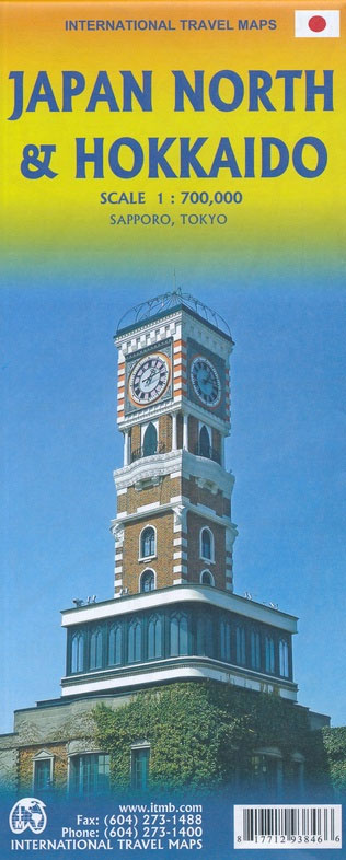
Northern Honshu and Hokkaido at 1:800,000 on a double-sided, indexed map from ITMB, with large, clear street plans of central Tokyo and Sapporo showing plenty of tourist information, plus an enlargement of the environs of Tokyo.On one side is the northern part of Honshu, approx. east of the Nagoya ‘“ Kanazawa line (i.e. without Kyoto and Osaka). Insets provide a street plan of central Tokyo plus an enlargement of the capital’s environs showing road and rail access from the Narita International Airport. On the reverse is Hokkaido with a street plan of central Sapporo.The map has altitude colouring to show the topography with peak names and heights, plus marking for volcanoes and national parks. Road network is graded into five types from expressways with tolls to secondary roads, with driving distances shown on selected routes. Railways distinguish between ordinary lines, bullet train routes and privatized lines. Ferry routes are shown and local airports are marked. The map also shows internal administrative boundaries with names of the provinces. Symbols highlight various places of interest and additional notes provide more information about selected sights. All place names are shown in Latin alphabet only. The map has latitude and longitude lines at intervals of 1ยฐ and each side has a separate index.The two street plan show names and locations of numerous hotels, various places of interest and facilities, etc.

Related Products:
 Japan South ITMB Railway & Road Map
 Tokyo & Central Japan ITMB
 Argentina North & Uruguay ITMB
 Osaka & Western Japan ITMB
 Kyoto & Japan West ITMB
 Japan ITMB
 Japan West & Central Railway & Road ITMB
 Japan Nelles
 Hanoi – Vietnam North ITMB
 Auckland & North Island ITMB
 Quito & Central Ecuador ITMB
 Saudi Arabia & Kuwait ITMB
 Middle East ITMB Travel Atlas
 Iran & Tehran ITMB
 Sao Paulo & Brazil South Coast ITMB
 India North East & Kolkata / Calcutta ITMB
 Bangladesh & India East ITMB
 Tehran & Northern Iran ITMB
 Santiago & Chile North ITMB
 Tel Aviv-Jaffa & Central Israel ITMB
 USA North-East
 Zurich & Switzerland NW ITMB
 Japan F&B
 Sydney & Australia East ITMB
 Argentina South & Tierra del Fuego ITMB
 Manhattan & New York State ITMB
 San Diego & USA South West Border ITMB
 Jordan & Syria ITMB
 Jerusalem & Holy Land ITMB
 Buenos Aires & Argentina North East ITMB
 Chile ITMB
 Pakistan ITMB
 Japan Railway & Road ITMB Travel Atlas
Sri Lanka & India South ITMB
Japan Railway & Road ITMB Travel Atlas
Sri Lanka & India South ITMB
 Paris & France North ITMB
 Taiwan & Taipei ITMB
 Easter Island & Santiago ITMB
 Mongolia ITMB