Disclosure : This site contains affiliate links to products. We may receive a commission for purchases made through these links.
Ivory Coast Michelin
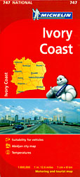
The Michelin National road map of Ivory Coast at 1:800,000 scale is ideal for trip & route planning. The map gives comprehensive coverage of national road networks showing all major motorways and main roads, and good coverage of unsurfaced roads, recognized tracks & shows a good deal of road surface type & quality information. The map is divided by grid showing latitude and longitude. Good coverage of smaller towns and settlements.Distances between major locations are marked along roads, with both total distance and several intermediate distances shown. A quick-reference chart of regional temperature & rainfall data is included, cross referenced to locations on the map. The map also includes a short textual description of the country’s climate, history, geography, economy and core statistics. The map is not indexed.Clear, easy-to read cartography shows roads in reds, yellows and white with black outlines. No topographical data is shown except some spot heights. Woodland & forest is marked with green shading. Built-up urban areas are shaded beige/brown. Airports, airfields & railways are marked. National and administrative region boundaries are clearly highlighted, as are national park boundaries.Tourist information includes:- Places of particular tourist interest- Scenic driving routes- Viewpoints & panoramas- Hotel-Restaurants, some with fuel/repair facilities- Tourist complexes/resorts & secluded hotels, camping sites & safari lodges Town plans & regional enlargements:- Abidjan region at 1:100,000 & Abidjan centre at 1:60,000

Related Products:
 Finland Michelin
 Hungary Michelin
 Sweden Michelin
 Baltic States Michelin
 Austria Michelin
 Norway Michelin
 Romania Michelin
 Portugal – Madeira Michelin
 Czechia Michelin
 Poland Michelin
 Czechia – Slovakia Michelin
 Slovenia – Croatia – Bosnia-Herzegovina – Serbia – Montenegro – North Macedonia Michelin
 Czechia – Slovakia Michelin SUPERCEDED
 Latvia Regio Manors and Palaces
 USA Michelin
 Brasov Region Tourist Map
 USA: Michelin Regional Road Maps
 Southeastern USA Michelin Regional 584
 Turkey Michelin
 Baltic Sea Coast – Hamburg – Berlin K+F Regional Map
 North Sea Coast – Bremen – Hamburg K+F Regional Road Map
 Madeira Michelin Regional 594
 Grand Est Michelin Maxi Regional 601
 New England – Hudson Valley Michelin Regional 581
 Paris & Surrounding Areas Michelin Regional 514
 Switzerland North Michelin Regional 551
 Greece Michelin
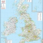 Great Britain & Ireland Michelin Wall Map PAPER
 Northeastern USA – Eastern Canada Michelin Regional 583
 China East ITMB
Switzerland South-West Michelin Regional 552
Switzerland South-East Michelin Regional 553
China East ITMB
Switzerland South-West Michelin Regional 552
Switzerland South-East Michelin Regional 553
 Poland: Michelin Regional Road Maps
 Carinthia – Northern Adriatic Coast F&B
 Western USA – South Western Canada Michelin Regional 585
 Czechia
 Ukraine South
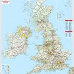 Great Britain & Ireland Michelin Wall Map ENCAPSULATED
 Aquitaine Michelin Regional 524