Disclosure : This site contains affiliate links to products. We may receive a commission for purchases made through these links.
Italy: Ed. Multigraphic Walking Maps of Central Italy
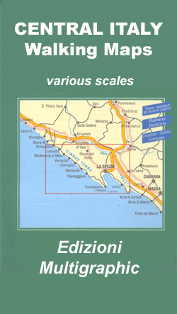
Hiking maps at 1:25,000 or 1:50,000 from the Florence-based Edizioni Multigraphic covering parts of Tuscany, Umbria and the adjoining regions of central Italy. The cartography is rather old fashioned and sometimes not as clear as in other map series but for some areas these are the only hiking maps currently obtainable. Most maps have contours at 25-metre intervals, with some relief shading and colouring for forests. An overprint highlights hiking paths, including all the popular hiking routes such as the Grandi Sentieri della Provincia di Siena, etc. The overprint also shows campsites and, where appropriate, mountain refuges and other types of alpine accommodation. Some maps indicate latitude and longitude at the map corners, but with longitude sometimes based on Rome rather than Greenwich. Map legends vary, most maps include English. Some titles also include street plans and additional notes on the region. For more details please see individual descriptions.Titles listed `out of stock` from this series will have to be ordered in and it can take 2 to 3 months.

Related Products:
 Italy: Edizioni Multigraphic 25K Walking Maps of Central Italy
 Italy: IGA 25K Hiking Maps of Central Italy
 Italy: IGA 50K Hiking Maps of Central Italy
 Italy: F&B Walking Maps of the Dolomites
 Italy: Tabacco 25K Walking Maps of the Dolomites and North-Eastern Italy
 Italy: IGC 50K Walking Maps of North-Western Italy
 Alta Maremma – Parco di Montioni 25K Ed. Multigraphic Map No. 507
 Parco della Maremma – Monti dell`e Uccellina Edizioni Multigraphic 504
 Versilia – Riviera Apuana – Alpi Apuane Edizioni Multigraphic 711
 Elba & the Tuscan Archipelago 25K Ed. Multigraphic Map No. 502
 S. Godenzo & the Surrounding Footpaths 25K Ed. Multigraphic Map No. 526
 Livorno Coast Edizioni Multigraphic 523
 Siena and Crete – Senesi West Edizioni Multigraphic 517
 Garfagnana Edizioni Multigraphic 701
 Italy: SER 25K Hiking Maps of Central Italy
Appennino Bolognese e Pistoiese Edizioni Multigraphic 21
Italy: SER 25K Hiking Maps of Central Italy
Appennino Bolognese e Pistoiese Edizioni Multigraphic 21
 Florence and Surroundings Edizioni Multigraphic 510
 Parco Regionale Migliarino – S. Rossore – Massaciuccoli Edizioni Multigraphic 503
 San Miniato Commune 25K Ed. Multigraphic Map No. 521
Bassa Lunigiana – Monte Marcello – Golfo della Spezia Edizioni Multigraphic 508
San Miniato Commune 25K Ed. Multigraphic Map No. 521
Bassa Lunigiana – Monte Marcello – Golfo della Spezia Edizioni Multigraphic 508
 Appennino Pistoiese – Monti Pesciatini Edizioni Multigraphic 22
 Chianti – Val di Pesa – Val d`Elsa Edizioni Multigraphic 512
 Italy: IGC 25K Walking Maps of the Italian Alps
 Crete Senesi 2 – Crete Senesi 25K Ed. Multigraphic Map No. 518
Chianti – Florence to Siena Edizioni Multigraphic 522
Crete Senesi 2 – Crete Senesi 25K Ed. Multigraphic Map No. 518
Chianti – Florence to Siena Edizioni Multigraphic 522
 Volterra and its Environs Edizioni Multigraphic 513
 Austria/Germany/Italy: Alpenverein Hiking & Ski Maps
Monte Amiata 25K Ed. Multigraphic Map No. 41
Austria/Germany/Italy: Alpenverein Hiking & Ski Maps
Monte Amiata 25K Ed. Multigraphic Map No. 41
 The Hills of Siena & Bosco di Lecceto 25K Ed. Multigraphic Map No. 509
Genoa – Varazze 25K Ed. Multigraphic Map No. 3/4
Casentino – Val Tiberina 25K Ed. Multigraphic Map No. 35
San Gimignano – Colle Val d`Elsa – Poggibonsi Edizioni Multigraphic 511
The Hills of Siena & Bosco di Lecceto 25K Ed. Multigraphic Map No. 509
Genoa – Varazze 25K Ed. Multigraphic Map No. 3/4
Casentino – Val Tiberina 25K Ed. Multigraphic Map No. 35
San Gimignano – Colle Val d`Elsa – Poggibonsi Edizioni Multigraphic 511
 Alpi Apuane Edizioni Multigraphic 101/102
 Gruppi Argentera e Marguareis Edizioni Multigraphic 109/115
Massiccio del Pratomagno 25K Ed. Multigraphic Map No. 31/32
Gruppi Argentera e Marguareis Edizioni Multigraphic 109/115
Massiccio del Pratomagno 25K Ed. Multigraphic Map No. 31/32
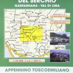 Media Valle del Serchio – Garfagnana – Val di Lima Edizioni Multigraphic 20
 Italy: Ed. Multigraphic 100K Road Maps of Tuscany & Adjoining Areas
Imperia – San Remo – Ventimiglia Edizioni Multigraphic 111/112
Italy: Ed. Multigraphic 100K Road Maps of Tuscany & Adjoining Areas
Imperia – San Remo – Ventimiglia Edizioni Multigraphic 111/112
 Appennino Bolognese e Pratese Edizioni Multigraphic 23
Valli del Bormida – Appennino Savonese 25K Ed. Multigraphic Map No. 1/2
Appennino Bolognese e Pratese Edizioni Multigraphic 23
Valli del Bormida – Appennino Savonese 25K Ed. Multigraphic Map No. 1/2