Disclosure : This site contains affiliate links to products. We may receive a commission for purchases made through these links.
Isle of Wight A-Z Visitors` Wall Map
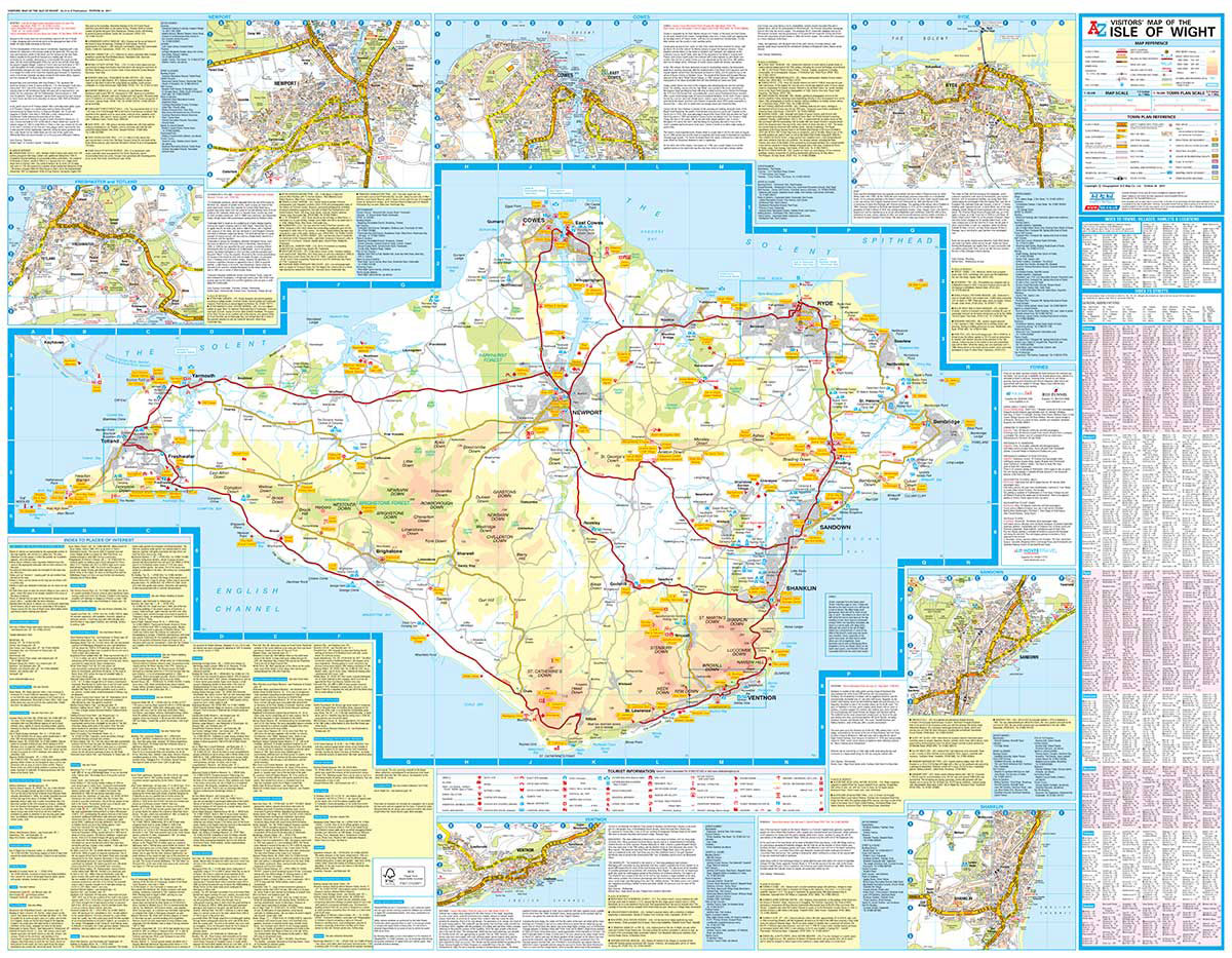
This full colour Visitors` Map of the Isle of Wight includes a detailed road map at a clear 1.5 miles to 1 inch (1:42,240) scale, town centre street maps, place of interest details, ferry information and much more.The road map features safety camera locations with speed limits; selected fuel stations, caravan and camping sites; visitor attractions and places of interest.There are town centre street maps of:Freshwater and TotlandNewportCowesRydeSandownShanklinVentnorEach town centre map includes descriptive text and useful information about its visitor attractions and places of interest.The Vistors` Map of the Isle of Wight is ideal for anyone wishing to explore the many attractions this beautiful island has to offer.

Related Products:
 Isle of Wight A-Z Visitors` Map
 Devon A-Z Visitors` Wall Map PAPER
 Lake District A-Z Visitors` Wall Map PAPER
 Peak District A-Z Visitors` Wall Map PAPER
 Lake District A-Z Visitors` Map
 Isle of Wight A-Z Pocket Map
 Isle of Wight OS Explorer OL29
 Isle of Wight – Short Walks
 Isle of Wight Street Atlas
 Portrait of the Isle of Wight
 Walking on the Isle of Wight: 24 Coastal and Countryside Walks and the Isle of Wight Coastal Path
 Hampshire & The Isle of Wight Cycle Tours
 50 Walks in Hampshire & Isle of Wight
 Isle of Wight Leisure and Tourist Map
 Isle of Wight A-Z Street Atlas
 Hampshire & Isle of Wight Sustrans Cycle Map 6
 South West Sea Kayaking: Isle of Wight to the Severn Estuary
 Isle of Wight From The Air
 Isle of Wight Pevsner Architectural Guide
 Y30 Isle of Wight
 Hampshire & Isle of Wight Cycling Country Lanes & Traffic-Free Family Routes
 Bicycle Island – Isle of Wight Heritage House Cycle Map
 Isle of Wight: Cowes 1907
 Isle of Wight Walkers Map
 Isle of Wight AA Walker`s Map 16
 Isle of Wight
 The Complete Isle of Wight Coastal Footpath
 Isle of Wight Walkers` Map
 The Isle of Wight, Portsmouth and The Solent
 Isle of Wight OS Explorer OL29 ACTIVE
 Isle of Wight (B&S) Special Sheet E330, 331, 344 & 345 NEW VERSION
 Isle of Wight by Bike Cycle Map
 Ventnor & Isle of Wight 1901 – 344/345
 Isle of Wight A-Z Adventure Atlas
 Cornwall A-Z Visitors` Map
 The Solent, Isle of Wight, Southampton & Portsmouth OS Landranger Map 196 (paper)
 Pocket Rough Guide British Breaks Isle of Wight (Travel Guide with Free eBook)
 The Rough Guide to Dorset, Hampshire & the Isle of Wight (Travel Guide with Free eBook)
 The Solent, Isle of Wight, Southampton & Portsmouth OS Landranger Active Map 196 (waterproof)
 Hampshire and the Isle of Wight 1884 Letts County Map