Disclosure : This site contains affiliate links to products. We may receive a commission for purchases made through these links.
Isle of Wight A-Z Visitors` Map
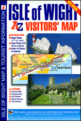
The Isle of Wight Visitors’ Map at 1:42,240 (.5″ to 1 mile) from A-Z with prominent highlighting of places of interest also listed in a separate index with contact details and brief descriptions, plus street plans of Freshwater and Totland, Newport, Cowes, Ryde, Ventnor and Shanklin, also with descriptions. Topography of the island is shown by altitude colouring with spot heights and names of downs and hills. Numerous places of interest are very prominently highlighted. Road network has gradient markings on steep roads, etc. The map has British national grid lines for GPS users. Two separate indexes list towns/villages and sights, all grouped thematically from abbeys or animal collections to windmills and zoos, most accompanied by brief descriptions and/or contact details.. Street plans of Freshwater and Totland, Newport, Cowes, Ryde, Ventnor and Shanklin are also indexed and accompanied by historical notes and information on sights.

Related Products:
 Isle of Wight A-Z Street Atlas
 Isle of Wight Leisure and Tourist Map
 Pocket Rough Guide British Breaks Isle of Wight (Travel Guide with Free eBook)
 Isle of Wight A-Z Visitors` Wall Map
 Walking on the Isle of Wight: 24 Coastal and Countryside Walks and the Isle of Wight Coastal Path
 Ventnor & Isle of Wight 1901 – 344/345
 Great Britain: A-Z Visitors` Maps and Atlases
 Portrait of the Isle of Wight
 Isle of Wight: Cowes 1907
 Hampshire & Isle of Wight Sustrans Cycle Map 6
 Bicycle Island – Isle of Wight Heritage House Cycle Map
 Isle of Wight A-Z Pocket Map
 Isle of Wight OS Explorer OL29
 Cape Town & the Peninsula Map Studio Visitors Guide
 2200 Solent Chart Pack: Selsey Bill to Poole, Including the Isle of Wight – 2021 edition
 The Isle of Wight, Portsmouth and The Solent
 Walk! The Isle of Wight
 The Rough Guide to Dorset, Hampshire & the Isle of Wight (Travel Guide with Free eBook)
 50 Walks in Hampshire & Isle of Wight
 Devon A-Z Visitors` Map
 Isle of Wight Coastal Path – 80 Miles
 Hampshire & The Isle of Wight Cycle Tours
 Isle of Wight AA Walker`s Map 16
 Isle of Wight – Short Walks
 Devon – Cornwall – West Somerset A-Z Visitors` Atlas & Guide
 Isle of Wight A-Z Adventure Atlas
 London A-Z Visitors` Map
 Pau Blay-Foldex Street Plan
 Brest
Brest
 Hyรจres Blay-Foldex Street Plan
 Mรขcon Blay-Foldex Street Plan
 Lyon Blay-Foldex Street Plan
 Montpellier Blay-Foldex Street Plan
 La Rochelle Blay-Foldex Street Plan
 Reims Blay-Foldex Street Plan
 Nimes Blay-Foldex Street Plan
 Orleans Blay-Foldex Street Plan
 Troyes Blay-Foldex Street Plan
 Albi Blay-Foldex Street Plan
 Arcachon Blay-Foldex Street Plan