Disclosure : This site contains affiliate links to products. We may receive a commission for purchases made through these links.
Inverleith & Canonmills 1896 – 3.03
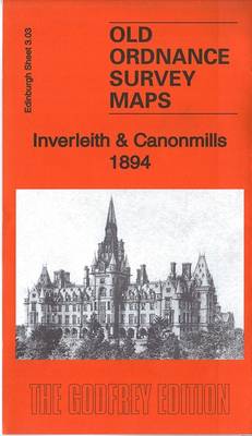
Inverleith and Canonmills areas of Edinburgh in 1896 in a fascinating series of reproductions of old Ordnance Survey plans in the Alan Godfrey Editions, ideal for anyone interested in the history of their neighbourhood or family. The map covers western Leith around Inverleith, stretching from Fettes College eastward to East Claremont Street, and from Granton Road station southward to Raeburn Place. Features include Royal Botanic Gardens, Inverleith House, Fettes College, Malcolm House, Comeley Bank area, Academy and Grange cricket grounds, St James church, Heriot Hill area, Canonmills area, Tanfield area, Beaverbank area, St Marks church, Powderhall Grounds, Edinburgh Cemetery, Chancelot Flour Mills, Silvermills area, NBR lines with Warriston Junction, Warriston Park, tramways etc. On the reverse is a selection of street directory entries, including Brandon Terrace, Eyre Crescent, Golden Acre Terrace, Henderson Row, Howard Place, Inverleith Avenue/Place/Row/Terrace, Royal Crescent, Scotland Street, Warriston Crescent and Cumberland Street. About the Alan Godfrey Editions of the 25″ OS Series:Selected towns in Great Britain and Ireland are covered by maps showing the extent of urban development in the last decades of the 19th and early 20th century. The plans have been taken from the Ordnance Survey mapping and reprinted at about 15 inches to one mile (1:4,340). On the reverse most maps have historical notes and many also include extracts from contemporary directories. Most maps cover about one mile (1.6kms) north/south, one and a half miles (2.4kms) across; adjoining sheets can be combined to provide wider coverage.FOR MORE INFORMATION AND A COMPLETE LIST OF ALL AVAILABLE TITLES PLEASE CLICK ON THE SERIES LINK.

Related Products:
 Harrogate 1908
 Southsea 1896 – 83.12a
Old Portsmouth & Gosport 1896 – 83.11a
Southsea 1896 – 83.12a
Old Portsmouth & Gosport 1896 – 83.11a
 Central Edinburgh 1894 – 3.07
Stranton & Southern Hartlepool 1896 – 37.15
Central Edinburgh 1894 – 3.07
Stranton & Southern Hartlepool 1896 – 37.15
 Hexham 1896
 Winchmore Hill 1896 – 7.10a
Washington 1896
Winchmore Hill 1896 – 7.10a
Washington 1896
 New Hartley and Delaval Hall 1896
 Camberley 1895
 Lanark 1896 – 25.15
 Barnet and Hadley 1896
 St. Andrews 1893 – 9.10
Shildon 1896
Easington Lane and Bryn Gates 1896
St. Andrews 1893 – 9.10
Shildon 1896
Easington Lane and Bryn Gates 1896
 Morningside 1893 – 3.15
 Watford South and New Bushey 1896
Kirkintilloch 1896
Sheffield (West) 1903 – 294.07b
Norton 1896
Central Nottingham 1899 – 42.02b
Watford South and New Bushey 1896
Kirkintilloch 1896
Sheffield (West) 1903 – 294.07b
Norton 1896
Central Nottingham 1899 – 42.02b
 Cambridge (North) 1901 – 40.14
Hamilton 1896
Cambridge (North) 1901 – 40.14
Hamilton 1896
 Holywood 1931
Drumsagard Hallside & Newton 1896 – 11.06
Holywood 1931
Drumsagard Hallside & Newton 1896 – 11.06
 Ramsgate 1905
 Monken Hadley 1896
Penryn 1906
Rock Ferry and New Ferry 1898
Crook East 1896
Monken Hadley 1896
Penryn 1906
Rock Ferry and New Ferry 1898
Crook East 1896
 City of York & Clifton 1907 – 174.06b
Newhaven & Granton 1904 – 1.15
Gravesend 1865
Sheffield Ecclesall Road and Sharrow 1903
Brecon 1903 – 28.13
Bishop Auckland 1896 – 42.02a
Wolverhampton North West 1901
Motherwell 1896
City of York & Clifton 1907 – 174.06b
Newhaven & Granton 1904 – 1.15
Gravesend 1865
Sheffield Ecclesall Road and Sharrow 1903
Brecon 1903 – 28.13
Bishop Auckland 1896 – 42.02a
Wolverhampton North West 1901
Motherwell 1896
 Shrewsbury West 1900
 Putney Bridge 1894 – 99.2