Disclosure : This site contains affiliate links to products. We may receive a commission for purchases made through these links.
Innsbruck City Map
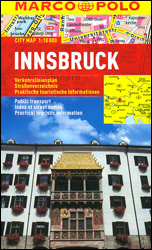
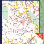
Innsbruck at 1:10,000 on a pocket-size street plan from MairDumont printed on durable, waterproof and tear-resistant synthetic paper, with tram and bus routes shown with stops and line numbers, a diagram of the IVB network, one way streets, lists of useful addresses, etc. An inset extends coverage to Igls and the city’s Olympic facilities.The plan covers Innsbruck with its outer districts and very clearly presents the city’s public transport options, as well as one way streets, car parks and pedestrianized areas. Important buildings and places of interest are highlighted. Multilingual map legend includes English.The index is on the reverse side and includes lists of useful contact details for tourist information offices, hotel reservation, car hire, places of entertainment, emergency services, etc. The map also includes a diagram of the IVB network and a small road map of the city’s environs.

Related Products:
 Helsinki City Map
 Rio de Janeiro Marco Polo City Map
 Warsaw Marco Polo City Map
 Prague Marco Polo City Map
 Berlin Marco Polo City Map
 Budapest Marco Polo City Map
 Innsbruck F&B Tourist Street Plan
 Hong Kong Marco Polo City Map
 St Petersburg Marco Polo City Map
 Florence Marco Polo City Map
 Palma de Mallorca City Map / Mallorca Road Map
 Brussels Marco Polo City Map
 Rome NGS City Destinations Map
 Cape Town Marco Polo City Map
 Bangkok Marco Polo City Map
 Barcelona Borch
 Istanbul Marco Polo City Map
 Nuremberg City Pocket Plan
 Porto Michelin City Plan and Index
 Riga City Center Jana Seta Street Plan
 Helsinki City Map & Guide
 Boston Marco Polo City Map
 Munich Marco Polo City Map
 Amsterdam Michelin City Map
 Valencia Michelin City Map
 Dublin City Centre Tourist Map
 New York City – Manhattan Michelin City Plan and Index
 Vienna Borch
 Bilbao Michelin City Map
 Sydney City Streets & Suburbs UBD Gregory`s 262
 Berlin Michelin City Map
 Brisbane UBD Gregory`s City Pocket 460
 Stockholm Tourist Map
 Moscow ITMB
 Athens City Map
 Lisburn City OSNI Street Plan
 Armagh City OSNI Street Plan
 Salzburg F&B Street Plan
Singapore Borch
Salzburg F&B Street Plan
Singapore Borch
 Innsbruck Mountain Adventures: Summer routes for a multi-activity holiday around the capital of Austria`s Tirol