Disclosure : This site contains affiliate links to products. We may receive a commission for purchases made through these links.
Indonesia ITMB
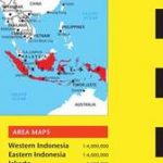
Indonesia at 1:2,400,000 on a double-sided indexed map from ITMB and cartography designed to show the country’s topography through bright altitude colouring and spot heights (elevation shown in feet). The map divides Indonesia west/east, with Sumatra, Borneo, Java, Bali, Lombok and Sumbawa on one side, and Sulawesi with the remaining islands and West Papua on the reverse. Individual small islands and groups are named, as are the surrounding seas, straights and bays.The map shows ferry connections between the islands and on the larger ones shows their road network with distances on main routes. Various places of interest are highlighted: national parks and other protected areas, cultural and religious places, beaches, snorkeling/diving/fishing sites, etc. some annotated with brief notes. Latitude and longitude lines are drawn at 2ยฐ intervals. Each side has a separate index.

Related Products:
 New Guinea (Papua New Guinea and Indonesia) ITMB
 Indonesia: Reise-Know How Regional Maps
 Indonesia: Nelles Regional Maps
 Indonesia Periplus Travel Map
 Hungary & Budapest ITMB
 Madagascar ITMB
 Cape Verde & West Africa ITMB
 Baltic States ITMB
 Mauritius & Reunion ITMB
 Montreal & Southern Quebec ITMB
 Tuttle Travel Pack Indonesia: Your Guide to Indonesia`s Best Sights for Every Budget
 Indonesia: Periplus Regional Maps
 Canary Islands ITMB
 Philadelphia & Mid-Atlantic States ITMB
 South East Asia ITMB
 Scotland ITMB
 Mongolia ITMB
 Los Angeles & Southern California ITMB
 Rome & Southern Italy ITMB
 Vietnam, Laos & Cambodia ITMB
 Oslo / Bergen & South of Norway ITMB
 Hong Kong & Region ITMB
 Cayman Islands & Jamaica ITMB
 Galapagos Islands – Quito & Guayaquil ITMB
 Bangkok & Thailand South ITMB
 Colombia ITMB
 Sri Lanka & India South ITMB
 Cuba West ITMB
New Zealand Wall Map
Cuba West ITMB
New Zealand Wall Map
 Barcelona & Catalonia ITMB
 Peru ITMB
 Vietnam ITMB
 Argentina South & Tierra del Fuego ITMB
 Albania ITMB
Malta & Gozo ITMB
Albania ITMB
Malta & Gozo ITMB
 Quito & Central Ecuador ITMB
 Patagonia & Tierra del Fuego ITMB
 Rocky Mountains Canada and US ITMB