Disclosure : This site contains affiliate links to products. We may receive a commission for purchases made through these links.
India South Borch
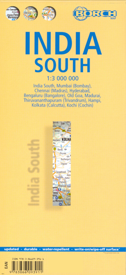
Laminated waterproof road map of southern India at 1:3,000,000 from Borch, with 1:30,000 plans of: Mumbai; Chennai; Hyderabad; Old Goa; Madurai; Thiruvananthapuram; Hampi; Kolkata; and Kochi. The main road network is shown with distances marked in kilometres, with minor roads and some country paths also displayed. Railway lines are marked. Spot heights are used to denote any topographical information. Points of interest such as monuments, places of worship, and national parks are clearly marked, as well as local facilities such as hospitals and post offices. Administrative and national boundaries are prominently marked.The street plans on the reverse of the map show most major road names, with bus and rail lines and stops marked where present, as well as points of interest.The map also provides a small map of Indian administrative and time zones, as well as a small box detailing climate, population and statistical data on IndiaAll maps are indexed. Map legend includes English.

Related Products:
 Sri Lanka & India South ITMB
 India North Borch
 Ireland Borch
 Phoenix Borch
 Miami Borch
 Rio de Janeiro Borch
 Tokyo Borch
 Bhutan & Northeast India ITMB
 Europe Borch
 Beijing Borch
 Bangladesh & India East ITMB
 Southeast USA – The South & Florida Borch
 Italy Borch
South Island – New Zealand Hema
Italy Borch
South Island – New Zealand Hema
 Venice Borch
Belarus (Cyrillic edition)
Venice Borch
Belarus (Cyrillic edition)
 Spain Borch
 Montrรฉal Borch
 Lisbon Borch
 Yucatan Borch
 Belize Borch
 New South Wales Hema
 Accra & Ghana South ITMB
 India South Nelles
 London Borch
 Korea South & North ITMB
 Las Vegas ITMB
 Toronto Borch
 Washington DC Borch
 USA Interstate Borch Road Map
 Angola
 Sydney Borch
 Ecuador Borch
 San Francisco Borch
 Chicago Borch
 Thailand Borch
 Aruba Borch
 Cuba Borch
 India Geographical Wall Map
 Istanbul Borch