Disclosure : This site contains affiliate links to products. We may receive a commission for purchases made through these links.
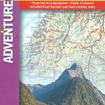
India South Adventure Map

Southern India at 1:1,400,000 approx. in a series of Adventure maps from the National Geographic Society with cartography provided by Reise Know-How. The map is double-sided and printed on light waterproof and tear-resistant plastic paper. Coverage extends across the western coast to Vadodra (Baroda), along the eastern coast to beyond Kakinada (Cocanada) and inland well north of Nagpur.Cartographic information provided by Reise Know-How has been adjusted to follow the house style of the NGS Adventure series with greater emphasis on the country’s topography. Altitude colouring in broader bands has been replaced here by contours at 500m intervals plus relief shading. National parks and other protected areas are highlighted.Road network includes selected local tracks and gives distances on main and on most secondary routes. Railway lines are included and local airports are marked. Internal administrative boundaries are shown with names of the states. Symbols highlight various places of interest including UNESCO world heritage sites, archaeological remains, temples and museums, viewpoints, beaches, etc. Latitude and longitude lines are drawn at 1ยฐ intervals and the map has an index of place names.Overall, the slightly smaller scale of the NGS map and the presentation of the road and rail networks make the original Reise Know-How edition far clearer than the NGS map.PLEASE NOTE: to ensure regular supplies and faster delivery to our customers we keep as regular stock the Reise Know-How edition whilst the NGS version can be ordered on request.

Related Products:
 India Northeast NGS Adventure Map 3012
 India Adventure Map
 Vietnam South NGS Adventure Map 3016
 Italy NGS Adventure Map 3304
 South Africa Adventure Map
 Vietnam North NGS Adventure Map 3015
 Thailand Adventure Map
 Ecuador – Galapagos NGS Adventure Map 3403
 Tuscany Adventure Map
 Sicily NGS Adventure Map 3310
 China East Adventure Map
 Mexico NGS Adventure Map 3108
 Egypt NGS Adventure Map 3202
 Southern France Adventure Map
 Nicaragua – Honduras – El Salvador NGS Adventure Map 3109
 India South Reise Know-How
 China Adventure Map
 Peru NGS Adventure Map 3404
 Southern Sweden and Norway Adventure Map
 Slovenia Adventure Map
 Argentina NGS Adventure Map 3400
 Ireland Adventure Map
 Australia Adventure Map
 Morocco NGS Adventure Map 3203
 Brazil NGS Adventure Map 3401
 Chile NGS Adventure Map 3402
 Spain – Portugal Adventure Map
 Northern Spain NGS Adventure Map 3306
 Australia East Adventure Map
 New Zealand Adventure Map
 Finland and Northern Scandinavia NGS Adventure Map 3300
 Guatemala NGS Adventure Map 3110
 France Adventure Map
 Cuba NGS Adventure Map 3112
 India Northwest Reise Know-How
 Sweden South Reise Know-How
 India Northeast Reise Know-How
 South West Coast Path 3 – South Cornwall A-Z Adventure Atlas
 South West Coast Path 4 – South Devon Adventure Atlas
 Corsica Adventure Map