Disclosure : This site contains affiliate links to products. We may receive a commission for purchases made through these links.
In the Footsteps of Picasso (Camรญ de Picasso) Hiking Trail

In the Footsteps of Picasso Hiking Trail (Camรญ de Picasso) on a GP compatible, contoured map at 1:25,000 from Editiorial Alpina, covering the route of a 59-km journey made by the painter in spring 1906 from Guardiola to Bellver de Cerdanya.The course of the trail is highlighted on a detailed map with contours at 10m intervals enhanced by relief shading, plus coloring to show different types of vegetation. Also indicated are other long-distance GR routes, plus shorter local PR paths. Symbols show locations of various types of tourist accommodation (hotels, guest houses, campsites, youth hostels, mountain shelters), restaurants, areas for climbing and potholing, horse riding facilities, botanical gardens and interesting tree specimens, etc. Road network shows locations of petrol stations and car parks. The map has a 1-km UTM grid, plus latitude/longitude margin ticks at 1’. Also provided is a route profile showing changes in altitude, plus brief descriptions of main places of interest. Map legend and the text include English.To see the list of all the maps from Editorial Alpina covering long-distance hiking routes please click on the series link.

Related Products:
 The Hermitage (Ruta de l`Ermitร ) Hiking Circuit
 Muntanyes Mร giques / Magical Mountains Hiking Trail
 Andorra Trail Running 40K Ed. Alpina Map
 Menorca – Camรญ de Cavalls – GR223 Editorial Alpina CATALAN
 Peaks of the Balkans Long-Distance Hiking Trail: Albania ‘“ Kosovo ‘“ Montenegro
 Cavalls del Vent – Cadi-Moixero Natural Park Hiking Circuit Editorial Alpina
 Selvaggio Blu Hiking Trail – Sardinia
 Val d`Aran by UTMB Editorial Alpina Trail running race Map
 Muntanyes de Llibertat Hiking Circuit
 The Hidden Lakes (Ruta dels Estanys Amagats) Hiking Circuit
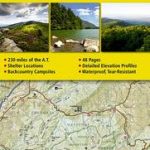
 USA: NGS Appalachian Trail Topographic Hiking Atlases
 Old Cross-Pyrenean Trail (Camino de Reencuentro): la Seu d`Urgell – Andorra – Auzat
 Appalachian Trail: Damascus to Bailey Gap Hiking Atlas, VA
 Tour of the Canigรณ Hiking Circuit
 South Loch Ness Trail Harvey National Trail XT40
 Carros de Foc Hiking Circuit Editorial Alpina
 Menorca – Camรญ de Cavalls – GR223 Editorial Alpina ENGLISH
 Appalachian Trail: Swatara Gap to Delaware Water Gap Hiking Atlas, PA
 Appalachian Trail: Bailey Gap to Calf Mountain Hiking Atlas, VA
 Appalachian Trail – Springer Mountain GA to Davenport Gap NC/TN NGS Hiking Atlas
 Appalachian Trail: Davenport Gap to Damascus Hiking Atlas, NC/VA
 Appalachian Trail: Delaware Water Gap to Schaghticoke Mountain Hiking Atlas, NJ/NY
 Appalachian Trail: Raven Rock to Swatara Gap Hiking Atlas, MD/PA
 Appalachian Trail: Hanover to Mount Carlo Hiking Atlas, NH/ME
 Appalachian Trail: Mount Carlo to Pleasant Pond Hiking Atlas, ME
 Appalachian Trail: Calf Mountain to Raven Rock Hiking Atlas, VA/WV/MD
 Transrhodopi – Long distance hiking and biking trail From Trigrad to Ivaylovgrad
 Kalymnos Trail Hiking Guide
 Alpe-Adria Trail: From the Alps to the Adriatic: Hiking Through Austria, Slovenia and Italy
 Appalachian Trail: Schaghticoke Mountain to East Mountain Hiking Atlas, CT/MA
 The Pacific Crest Trail: Hiking America`s Wilderness Trail
 Garrotxa – Zona Volcanica Editorial Alpina
 Skye Trail Harvey National Trail XT40
 The Fifth Lake (El Cinque Llac) Hiking Circuit
La Alta Ruta de los Perdidos – Monte Perdido – Vignemale Editorial Alpina Hiking Circuit Map
The Fifth Lake (El Cinque Llac) Hiking Circuit
La Alta Ruta de los Perdidos – Monte Perdido – Vignemale Editorial Alpina Hiking Circuit Map
 John Muir Trail: The Essential Guide to Hiking America`s Most Famous Trail
 Sardinia South-West: The Mining Coast Hiking Trail Guide
 Serra de Tramuntana Editorial Alpina 4-Map Set
 Vall Fosca – Montsent de Pallars Editorial Alpina 2-Map Set
 Cape Wrath Trail South – Fort William to Strathcarron Harvey National Trail XT40