Disclosure : This site contains affiliate links to products. We may receive a commission for purchases made through these links.
Icod de los Vinos CNIG Topo 1091
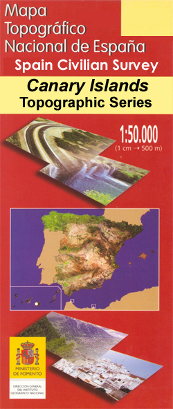
Icod de los Vinos area of Tenerife, map No. 1091 in the topographic coverage of the Canary Islands at 1:50,000 from the Instituto Geogrรกfico Nacional – Centro Nacional de Informaciรณn Geograficรก, Spain’s civilian survey organization. Maps in the MTN50 (Mapa Topogrรกfico Nacional) series begun in late 1990s have contours at 20m intervals enhanced by relief shading, plus colouring and/or graphics to show different types of terrain, vegetation or land use. Boundaries of national parks and other protected areas are marked. In addition to all the usual information shown on topographic maps at this scale, detailed presentation of the road and rail networks, rural tracks and paths, etc, the maps also show campsites and mountain refuges. The maps have a 1-km UTM grid, with margin ticks for latitude and longitude at 1` intervals. Map legend is in Spanish only. PLEASE NOTE: not all the maps may as yet reflect the changes in road numbering on the islands.To see other titles in this series please click on the series link.

Related Products:
 Icod de Los Vinos CNIG Topo 1091-2
La Montaรฑeta CNIG Topo 1091-4
Santiago del Teide – Tenerife CNIG Topo 1091-3
Buenavista del Norte – Tenerife CNIG Topo 1091-I
Icod de Los Vinos CNIG Topo 1091-2
La Montaรฑeta CNIG Topo 1091-4
Santiago del Teide – Tenerife CNIG Topo 1091-3
Buenavista del Norte – Tenerife CNIG Topo 1091-I
 Yaiza CNIG Topo 1081
Arrecife CNIG Topo 1082
Antigua CNIG Topo 1093
Haria CNIG Topo 1080
Los Cristianos CNIG Topo 1102
Telde CNIG Topo 1104
Gomera CNIG Topo 1095-1101
Los Canarios CNIG Topo 1087
El Castillo CNIG Topo 1094
Puerto del Rosario CNIG Topo 1090
Gran Tarajal CNIG Topo 1100
San Cristobal de la Laguna CNIG Topo 1088
Guia de Isora CNIG Topo 1096
Corralejo CNIG Topo 1086
Morro Jable CNIG Topo 1099
Playa Blanca CNIG Topo 1084
Puerto de la Cruz CNIG Topo 1092
Los Sauces CNIG Topo 1083
Playa del Ingles CNIG Topo 1109
Ingenio CNIG Topo 1107
Puerto Rico CNIG Topo 1106
Las Palmas de Gran Canaria CNIG Topo 1098
Hierro CNIG Topo 1105-1108
Isla de Alegranza CNIG Topo 1079
Granadilla de Abona CNIG Topo 1097
Santa Cruz de Tenerife CNIG Topo 1089
San Nicolas de Tolentino CNIG Topo 1103
Santa Cruz de la Palma CNIG Topo 1085
Yaiza CNIG Topo 1081
Arrecife CNIG Topo 1082
Antigua CNIG Topo 1093
Haria CNIG Topo 1080
Los Cristianos CNIG Topo 1102
Telde CNIG Topo 1104
Gomera CNIG Topo 1095-1101
Los Canarios CNIG Topo 1087
El Castillo CNIG Topo 1094
Puerto del Rosario CNIG Topo 1090
Gran Tarajal CNIG Topo 1100
San Cristobal de la Laguna CNIG Topo 1088
Guia de Isora CNIG Topo 1096
Corralejo CNIG Topo 1086
Morro Jable CNIG Topo 1099
Playa Blanca CNIG Topo 1084
Puerto de la Cruz CNIG Topo 1092
Los Sauces CNIG Topo 1083
Playa del Ingles CNIG Topo 1109
Ingenio CNIG Topo 1107
Puerto Rico CNIG Topo 1106
Las Palmas de Gran Canaria CNIG Topo 1098
Hierro CNIG Topo 1105-1108
Isla de Alegranza CNIG Topo 1079
Granadilla de Abona CNIG Topo 1097
Santa Cruz de Tenerife CNIG Topo 1089
San Nicolas de Tolentino CNIG Topo 1103
Santa Cruz de la Palma CNIG Topo 1085
 Felanitx CNIG Topo 725-1
Andratx CNIG Topo 697-4
Soller CNIG Topo 670-2
Felanitx CNIG Topo 725-1
Andratx CNIG Topo 697-4
Soller CNIG Topo 670-2
 Andraitx CNIG Topo 697
Inca CNIG Topo 671
Porreres CNIG Topo 699
Macanor CNIG Topo 700
Alaior CNIG Topo 646
Andraitx CNIG Topo 697
Inca CNIG Topo 671
Porreres CNIG Topo 699
Macanor CNIG Topo 700
Alaior CNIG Topo 646