Disclosure : This site contains affiliate links to products. We may receive a commission for purchases made through these links.
Ibiza – Formentera Editorial Alpina
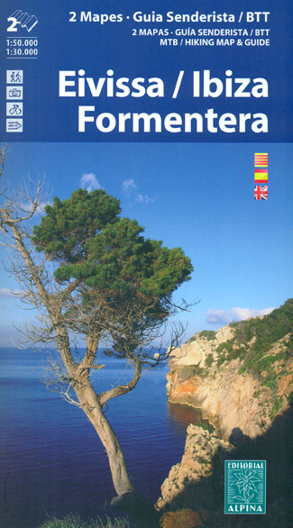
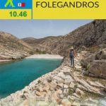
Ibiza at 1:50,000 and Formentera at 1:30,000 on a contoured and GPS compatible map from Editorial Alpina highlighting hiking, cycling and mountain bike routes, with English language descriptions of several recommended trails on both islands.The map is double-sided, presenting on one side Ibiza at 1:50,000 with contour lines at 20m intervals, with Formentera on the reverse at 1:30,000 and contours at 10m intervals. Both maps have numerous spot heights and names of mountain rangers, plus additional colouring indicating various types of vegetation. An overprint highlights hiking paths plus cycling and mounting biking routes, where appropriate cross-referencing them to the descriptions in the booklet. Symbols indicate campsites and other accommodation, climbing sites and equestrian centres, wine cellars, etc. Road network shows locations of bus stops, car parks and petrol stations. The maps have a UTM grid lines at 5km and 1km respectively. Map legend includes English.The accompanying booklet has 30 pages in English and provides descriptions on Ibiza of 12 hiking and 8 mountain bike routes, plus of the 203km cycling circuit of the island. For Formentera there are descriptions of five hiking trails.

Related Products:
 Ibiza – Formentera Kompass 239
 Ibiza – Formentera F&B
 Ibiza – Formentera
 Mallorca North Walking & Cycling Map & Guide Editorial Alpina
 Caps del Nord – Mallorca Editorial Alpina 2-Map Set
 Ibiza and Formentera Sunflower Landscape Guide
 Puigsacalm – Bellmunt Editorial Alpina
 Mallorca Central Plain – East and South Coasts Editorial Alpina
 Mallorca – Ibiza – Menorca – Formentera K+F Road Map
 Menorca – Camรญ de Cavalls – GR223 Editorial Alpina CATALAN
 Montseny Editorial Alpina
Cingles de Berti – Sant Miquel des Fai Editorial Alpina
Garraf – la Morella – Eramprunya Editorial Alpina
Montseny Editorial Alpina
Cingles de Berti – Sant Miquel des Fai Editorial Alpina
Garraf – la Morella – Eramprunya Editorial Alpina
 Montseny NP – Turo de l`Home – Les Agudas – Matagalls – la Calma Editorial Alpina 2-Map Set
 Cabo de Gata-Nรญjar Natural Park Editorial Alpina
Collserola Parc Natural Editorial Alpina
Cabo de Gata-Nรญjar Natural Park Editorial Alpina
Collserola Parc Natural Editorial Alpina
 Rasos de Peguera – Serra d`Ensija Editorial Alpina
 Ripollรจs Editorial Alpina
 Catllarร s – Picancel Editorial Alpina
 Mallorca – Ibiza – Formentera – Menorca Marco Polo Map
Spain: Editorial Alpina Walking Maps
Mallorca – Ibiza – Formentera – Menorca Marco Polo Map
Spain: Editorial Alpina Walking Maps
 Delta of the Ebro ‘“ Serra de Montsiร Editorial Alpina
 Congost de Mont-rebei Editorial Alpina
 Valles de Belagua y Roncal Editorial Alpina
 Cap de Creus Park Natural Editorial Alpina
 Menorca – Camรญ de Cavalls – GR223 Editorial Alpina ENGLISH
 Val d`Aran – Mauberme – Montardo – Molieres Editorial Alpina
 Muntanya d’Alinyร Editorial Alpina
Sant Llorenc del Munt i l`Obac Editorial Alpina
Muntanya d’Alinyร Editorial Alpina
Sant Llorenc del Munt i l`Obac Editorial Alpina
 El Turbรณn ‘“ Alto Valle de Isรกbena Editorial Alpina
Valles de Ansรณ & Echo Editorial Alpina
El Turbรณn ‘“ Alto Valle de Isรกbena Editorial Alpina
Valles de Ansรณ & Echo Editorial Alpina
 Mallorca – Tramuntana South Editorial Alpina
Val d`Aran by UTMB Editorial Alpina Trail running race Map
Mallorca – Tramuntana South Editorial Alpina
Val d`Aran by UTMB Editorial Alpina Trail running race Map
 Mallorca – Tramuntana Central Editorial Alpina
 Pica d`Estats – Mont-roig Editorial Alpina
 Montgrony – Fonts del Llogregat – Parc Natural del Cadรญ-Moixerรฒ Editorial Alpina
 Garrotxa – Zona Volcanica Editorial Alpina
 Mallorca – Tramuntana North Editorial Alpina
Moixerรณ – La Tosa – Cadรญ-Moixerรณ Natural Park Editorial Alpina
Mallorca – Tramuntana North Editorial Alpina
Moixerรณ – La Tosa – Cadรญ-Moixerรณ Natural Park Editorial Alpina
 Valle de Canfranc – Valle de Aisa – Candanchu – Astun Editorial Alpina