Disclosure : This site contains affiliate links to products. We may receive a commission for purchases made through these links.
Ibiza – Formentera
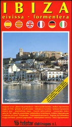
Ibiza and Formentera on an indexed road map at 1:92,500 from Telstar with on the reverse clear, indexed street plans of Ibiza’s main tourist destinations: Eivissa with coverage extending along the coast to Platja d’en Bossa and the Talamanca Bay ‘“ plus an enlargement of Eivissa’s Old Town, also Santa Eularia des Riu, the Bay of Portmany including Sant Antoni, Es Canar, Cala Longa and Portinaxt. The plans highlight car parks and petrol stations, taxi ranks, bus stops, etc.The map of the two islands shows the road network with locations of fuel supplies, and highlights various places of interest, including campsites, beaches, historical and archaeological remains, etc. Topography is shown by altitude colouring. The map has no geographical coordinates. The index is next to the map.Accompanying text provides suggestions for four hiking routes. Map legend and the text include English.

Related Products:
 Ibiza – Formentera F&B
 Ibiza – Formentera Kompass 239
 Ibiza – Formentera Editorial Alpina
 Mallorca – Ibiza – Menorca – Formentera K+F Road Map
 Ibiza and Formentera Sunflower Landscape Guide
 Mallorca – Ibiza – Formentera – Menorca Marco Polo Map
 Eivissa: The Ibiza Cookbook
 Pocket Rough Guide Ibiza and Formentera
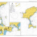
 Admiralty Chart 1701 – Cabo de San Antonio to Villanueva y Geltru including Islas de Ibiza and Formentera
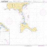
 Admiralty Chart 2834 – Ibiza and Formentera
 Zambia & Eastern Africa ITMB Road Map
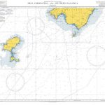 Admiralty Chart 1702 – Ibiza- Formentera and Southern Mallorca
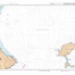
 SHOM Chart 7783 – Isla de Ibiza – Partie Sud et Isla de Formentera
 SHOM Chart 7669 – De Cabo de la Nao au port de Sagunto Isla de Ibiza et Isla de Formentera
 SHOM Chart 7783L – Isla de Ibiza – Partie Sud et Isla de Formentera – Leisure A4 size
 SHOM Chart 7669L – De Cabo de la Nao au port de Sagunto Isla de Ibiza et Isla de Formentera – Leisure A4 size
 SHOM Chart 7660 – De Cabo Tiรฑoso ร Cabo Canet – Islas Ibiza, Formentera, Cabrera et Cรดte Sud-Ouest de Mallorca
 M13 Denia to Barcelona and Ibiza
 Ibiza: The Coolest Hotspots
 SHOM Chart 7660L – De Cabo Tiรฑoso ร Cabo Canet – Islas Ibiza, Formentera, Cabrera et Cรดte Sud-Ouest de Mallorca – Leisure A4 size
 Ibiza Z-Map
 Aruba Borch
 Mozambique Pocket Map
Lesotho Map Studio Adventure Map
Mozambique Pocket Map
Lesotho Map Studio Adventure Map
 Slovakia Road Atlas
 Eivissa 25K Ibiza CNIG Topographic Survey Map No. 798-IV
Montenegro Coast
Eivissa 25K Ibiza CNIG Topographic Survey Map No. 798-IV
Montenegro Coast
 DK Eyewitness Travel Guide Mallorca, Menorca & Ibiza
 Ibiza Marco Polo Pocket Travel Guide 2019 – with pull out map
 Athens Borch
Alentejo Turinta
Athens Borch
Alentejo Turinta
 Yucatan Borch
 Cuba Borch
 Murcia
 Patagonia & Tierra del Fuego ITMB
 Chile Borch
 Libya Reise Know-How
 Malta – Gozo Kompass 235
 South-Western Nicaragua – Masaya – Granada
 Lonely Planet Pocket Ibiza