Disclosure : This site contains affiliate links to products. We may receive a commission for purchases made through these links.
Huilo Huilo Biological Reserve Trekkingchile Map
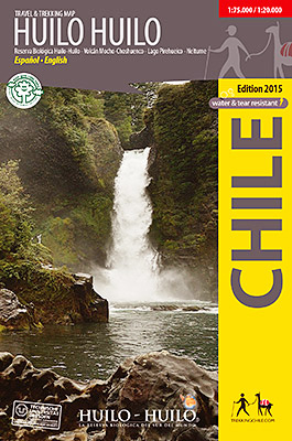
Huilo Huilo area around Neltume and Puerto Fuy near the Argentinian border at 1:75,000 on a waterproof and tear-resistant, contoured and GPS compatible map form Trekkingchile, with an enlargement at 1:20,000 and beautiful drawings of the local fauna and flora.On one side is a map at 1:75,000, centred on Neltune, Puerto Fuy, Lake Pirehueico and Moscho-Choshuenco Volcano. Coverage extends north beyond Liquiรฑe, Contours are at 50m intervals with colouring and graphics showing different types of vegetation. The map shows local roads, paths and trekking trails, as well as shipping routes on the lakes. Symbols highlight various accommodation facilities (hotels, campsites, refuges), eateries and grocery stores, sport and recreational sites, etc. The map has a 2-km UTM grid, plus margin ticks for latitude and longitude at 1’.On the reverse the central part around Neltume and Puerto Fuy is shown in greater detail at 1:20,000 with more facilities. Both maps include a list of recommended local treks. The map is illustrated with lovely drawings of local fauna and flora.Maps in the Trekkingchile series use satellite imagery as a base, with contour lines and colouring to indicate different types of terrain and habitats. Unless indicated to the contrary in the individual descriptions, the maps have a UTM grid, plus margin ticks for latitude and longitude. The maps are annotated with tourist information and most titles include a street plan of the region’s main town. Many are illustrated with drawings of local fauna or flora. Map legends and other text include English.To see the other titles in this series please click on the series link.


