Disclosure : This site contains affiliate links to products. We may receive a commission for purchases made through these links.
Historic Maps and Views of New York
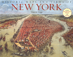
Historic Maps and Views of New York” has 24 reproductions of old maps and panoramic views dating from 1600s to the present; each one is removable and ready for framing in a custom format or in a standard 11″ x 14″ frame (28x36cm).This fascinating collection includes one of the earliest known maps of Manhattan, a detailed map of Central Park, a complete topographical map of then island of Manhattan, overviews of Brooklyn and Queens and much more.Each map’s original printing information is provided, as well as additional information that places it in historic context and further illuminates its qualities. Each map has been carefully reproduced to exemplify both colour and detail.

Related Products:
 Historic Maps and Views of Paris
 New York City – Brooklyn – Long Island City Red Maps
 New York City Red Maps
 New York F&B City Pocket Map
 New York City – Midtown Red Maps
 Seeking New York: The Stories Behind the Historic Architecture of Manhattan – One Building at a Time
 New York City
 New York City 5-Borough Rand McNally
 New York City – SoHo – NoLita – Little Italy Red Maps
 World 3 Global Views Raven Maps Physical Wall Map
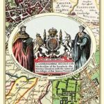 A Collection of Four Historic Maps of Cambridgeshire from 1611-1836
 Fodor`s New York City 2020
 New York: Writing Manhattan Map/Guide
 Colour New York: 20 Views to Colour in by Hand
 Old Folding Maps Reproductions of Historical Maps
 Lonely Planet New York City Guide
Historic Counties Maps Collection
Lonely Planet New York City Guide
Historic Counties Maps Collection
 Pocket Rough Guide New York City: (Travel Guide with free eBook)
 111 Rooftops in New York That You Must Not Miss
Historic City & Town Maps
111 Rooftops in New York That You Must Not Miss
Historic City & Town Maps
 The New York Nobody Knows: Walking 6,000 Miles in the City
 The Bowery Boys: Adventures in Old New York: An Unconventional Exploration of Manhattan`s Historic Neighborhoods, Secret Spots and Colourful Characters
 New York Raven Maps Physical Wall Map PAPER
 Lonely Planet Best of New York City
 New York City – Manhattan Michelin City Plan and Index
 New York Mapguide
 Windsor and Eton: British Historic Towns Atlas: Volume IV
 The Rough Guide to New York City
 Queens Noir
 New York: Eating Queens Map/Guide
 Poland: Reise-Know-How Touring Maps with Historic Place Names
 Insight Guides Explore New York
New York in 50 Maps: 750 Places for Urban Adventures
Insight Guides Explore New York
New York in 50 Maps: 750 Places for Urban Adventures
 New York City Borch
 New York City Fridge Magnets
 Chelsea NYC – High Line – Hudson Yards – West Village – Meatpacking District Red Maps
 DK Eyewitness Family Guide New York City
 Manhattan: Mapping the Story of an Island
 Brandenburg: Historic Town Centres Cycle Tours Part 2 (1000km) Bikeline Map/Guide
 Manhattan Borch