Disclosure : This site contains affiliate links to products. We may receive a commission for purchases made through these links.
Heston 1935
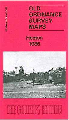
Heston in 1935 in a fascinating series of reproductions of old Ordnance Survey plans in the Alan Godfrey Editions, ideal for anyone interested in the history of their neighbourhood or family. Two versions have been published for this area. The 1894 map shows Heston as a rural Middlesex village, surrounded by orchards or market gardens and open countryside to the west, with a clutch of roads or lanes (Fern Lane, Norwood Green Road, Smoky Lane, Church Lane), St Leonard`s church, some pubs, Heston Hall, Heston Farm and a few other buildings. To the south is the hamlet of Sutton. Cranford Lane meanders across the map. The 1935 map is more developed and includes Heston Airfield; scheduled services started here in 1933 with flights to the Isle of Wight and Chamberlain famously flew from here to meet Hitler. This map includes a 1933 directory of Heston.About the Alan Godfrey Editions of the 25″ OS SeriesSelected towns in Great Britain and Ireland are covered by maps showing the extent of urban development in the last decades of the 19th and early 20th century. The plans have been taken from the Ordnance Survey mapping and reprinted at about 15 inches to one mile (1:4,340). On the reverse most maps have historical notes and many also include extracts from contemporary directories. Most maps cover about one mile (1.6kms) north/south, one and a half miles (2.4kms) across; adjoining sheets can be combined to provide wider coverage.FOR MORE INFORMATION AND A COMPLETE LIST OF ALL AVAILABLE TITLES PLEASE CLICK ON THE SERIES LINK.

Related Products:
 New Brighton 1935
 West Drayton South 1935
 Edgware 1935
 Alexandra Park and South Friern 1935
 Muswell Hill 1935 – 11.4
 Northwood Hills 1935
 Hornsey & Green Lanes 1935 – 12.4
 Wood Green 1935 – 7.4
 Southall Green 1935
 Harefield 1935
 Ashford (Middx) 1935 – 24.04
 South Acton & Gunnersbury Park 1935 – 71.4
 Northolt 1935
 South Harrow and Northolt Park 1935
 Harlington and Cranford 1935
Tannochside & North Uddingston 1935 – 11.03
Harlington and Cranford 1935
Tannochside & North Uddingston 1935 – 11.03
 Wealdstone and Hatch End 1935
Brentford 1935 – 83.4
Bellshill 1935 – 11.08
New Brighton 1909
Wealdstone and Hatch End 1935
Brentford 1935 – 83.4
Bellshill 1935 – 11.08
New Brighton 1909
 Alexandra Park & South Friern 1894 – 6a
 Alexandra Park & South Friern 1911 – 6b
Edgware 1895
Alexandra Park & South Friern 1911 – 6b
Edgware 1895
 Muswell Hill 1913 – 11.3
Easington Lane and Bryn Gates 1896
Muswell Hill 1913 – 11.3
Easington Lane and Bryn Gates 1896
 Newquay West 1933
South Shields 1895
Newquay West 1933
South Shields 1895
 Tottenham (North) 1894 – 8a
Harborne South 1901
Wisbech 1900
Ruislip 1939
Wanstead 1915 – 24.3
Willesden and Stonebridge Park 1936
Tottenham (North) 1894 – 8a
Harborne South 1901
Wisbech 1900
Ruislip 1939
Wanstead 1915 – 24.3
Willesden and Stonebridge Park 1936
 Snaresbrook 1939
Quinton 1902
Hindley Green 1906
Snaresbrook 1939
Quinton 1902
Hindley Green 1906
 Leeds South and South East 1906
Hornsey 1894 – 12.2
Leeds South and South East 1906
Hornsey 1894 – 12.2
 Hanworth and North West Hampton 1934
 Hazel Grove 1897