Disclosure : This site contains affiliate links to products. We may receive a commission for purchases made through these links.
Helgeland Coast North Nordeca Tourist Route 20013

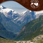
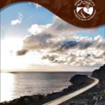
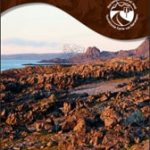
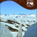
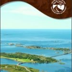
This Helgeland Coast National Tourist Route Map belongs to a series of 18 map and postcards sets describing popular tourist routes all over Norway. The map set includes a map in 1: 125,000 presenting an accurate topography (based on the Norwegian topographic survey) which describes local footpaths, cycle or ski routes, sport and recreational facilities, places of interest, places to stay and eat, viewpoints.Helgeland Coast National Tourist Route in the county of Nordland runs between Holm and Godรธystraumen and is 433 kilometres long, including the detour to Torghatten which is also part of the route. The main urban centres are Brรธnnรธysund and Sandnessjรธen in the south, and รrnes in the north.Driving up the road you will cross the Arctic Circle and enter the land of the midnight sun. The mild coastal climate provides an abundant flora, and the sharp mountain peaks and wild rivers offer many outdoor activity opportunities. The southern stretch of the road is a journey through lush nature, with the ocean, sheltered bays and beaches on the seaward side of the road and mountains and peaks on the other. This coast is rich in tradition, legends and stories.The Vega Islands are on UNESCO`s World Heritage List. The Seven Sisters north of Alstahaug and Torghatten south of Brรธnnรธysund are well known natural attractions along this stretch of road. They are a range of seven mountains, all more than 1,000 metres above sea level. The 160 metre-long hole through the Torghatten Mountain was created in the ice age. In the north the road winds along coast and sea, mountain and glacier and crosses the Arctic Circle towards the midnight sun of summer and the-round-the clock darkness of winter.Thanks to the Gulf Stream, Helgeland`s nature is rich and fertile. The sea-lanes along this coast were once the country`s main thoroughfare for north-south travel. The Svartisen Glacier is easily seen from the road, a 350 square kilometre demonstration of frozen power. An arm of the glacier, the Engabreen Glacier, reaches down from 1,200 metres above sea level and almost to the fjord itself.Beyond the tourist route, more than 14,000 islands stretch out into the ocean, offering a wealth of activity and experiences. The islands of the Helgeland Coast have been made accessible to travellers by ferries and express boats.Several descriptions and illustrations are included in the map to deliver a good visual representation of the trip.The set features:One map: scale 1:125,000 Text in three languages (Norwegian, English and German)5 Postcards (13.5x25cm)To see the list of other titles in this series, please click on the series link.

Related Products:
 Old Strynefjellsvegen Nordeca Tourist Route 20009
 Havoysund Nordeca Tourist Route 20017
 Varanger Nordeca Tourist Route 20018
 Sognefjellet Nordeca Tourist Route 20008
 Atlantic Road Nordeca Tourist Route 20012
 Lofoten Nordeca Tourist Route 20014
 Ryfylke Nordeca Tourist Route 20002
 Aurlandsfjellet Nordeca Tourist Route 20005
 Valdresflye Nordeca Tourist Route 20006
 Gaularfjellet Nordeca Tourist Route 20007
 North Wales – Lon Eifion – Lon Las Cefni – North Wales Coast Route Sustrans Cycle Map 24
 Coast & Castles Cycle Route North: Edinburgh – Aberdeen
 North Sea Coast Cycle Route 3 – Hamburg to Danish Border
 North Coast Journey Nicolson Road Map
 North Sea Coast Cycle Route 2 – Ems to Hamburg Bikeline Map-Guide
 North Sea Coast Cycle Route Part 4: Tรธnder – Skagen (500km) Bikeline Map/Guide
 North Sea Coast Cycle Route 1 – Rotterdam to Leer Bikeline Map-Guide
 North Sea Coast Cycle Route Part 1: Rotterdam – Leer (455km) Bikeline Map/Guide
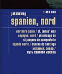 Spain North – Santiago Route Reise Know-How
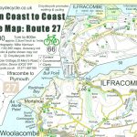 Devon Coast to Coast – Route 27 Cycle Map 66
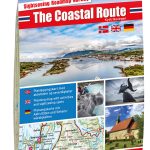 The Coastal Route Nordeca Sightseeing Map 6009
 South Coast East Sustrans Cycle Route Map
 SHOM Charts for the South West Coast of France – North Coast of Spain
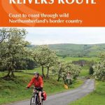 Cycling the Reivers Route: Coast to coast through wild Northumberland`s border country
 Coast to Coast West Mountain Bikers & Cyclists: St Bees to Kirkby Stephen
 Coast to Coast East Mountain Bikers & Cyclists: Kirkby Stephen to Robin Hood`s Bay
 John O`Groats & North Scottish Coast Cycle Map
 Garden Route & Route 62 Map Studio
 North Sea Coast – Bremen – Hamburg K+F Regional Road Map
 Way of the roses: The official guide to the national cycle network coast to coast cycle route from Morecambe to Bridlington
 Walking on Gran Canaria: 45 day walks including five days on the GR131 coast-to-coast route
 Tour de Manche Vol. 1: North-West Normandy – Channel Is. – South Dorset Cycle Route (505km)
 Lรดn Las Cymru Cycle Route North: Holyhead – Llanidloes
 Hadrian`s Cycleway: Coast-to-coast cycling from Ravenglass to South Shields
 Schleswig-Holstein North Sea Coast with Islands Cycling Map
 The North West Trail Cycle Route
 North Wales Coast – Chester to Bangor – Wales Coast Path Map-Booklet
 The North Coast 500 Guide Book: 2017
 Pacific Coast Route: Seattle to San Diego
 Atlantic Coast Route: Ft. Kent, ME to Key West, FL