Disclosure : This site contains affiliate links to products. We may receive a commission for purchases made through these links.
Hawaii NGS Wall Map PAPER
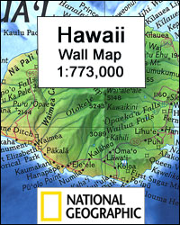
Hawaii Wall Map at 1:773,000 from the National Geographic Society, size 88 x 57.5cm (35″ x 22.5″ approx) with a vivid presentation of the topography of the islands and the sea floor of the Pacific Ocean. An inset shows the whole Hawaiian archipelago, from Hawaii (the Big Island) itself in the east to Kure Atoll in the Northwestern Hawaiian Islands Coral Reef Ecosystem Reserve.Presentation of the larger islands on the main map, from Hawaii to Niihau, very effectively uses relief shading to show the volcanoes, indicating areas of lava flow. The islands have numerous spot heights (in feet) and plenty of names of geographical features, particularly along the coast. The surrounding seas are coloured to indicate the Hawaiian Ridge on which the islands sit and the sea floor. On individual islands the map shows main towns and villages, principal roads and airports. Latitude and longitude lines are drawn at 1ยฐ intervals.The inset shows the whole of the Hawaiian Archipelago, with additional arrows indicating trade winds and ocean currents. The accompanying notes explain the administrative status, i.e. the state of Hawaii does not include the Midway Islands which are administered by the US Navy.

Related Products:
 Hawaii Raven Maps Physical Wall Map PAPER
 Hawaii Easy-to-Read Rand McNally
 Hawaii NGS Adventure Map 3111
 DK Eyewitness Travel Guide Hawaii
 Hawaii – Maui – Molokai – Lanai Nelles
 Hawaii – Travellers` Wildlife Guides
 Alaska NGS Wall Map PAPER
 Hawaii – Kauai Nelles
 USA: The Essential Geography of the United States of America Wall Map PAPER
 Japan NGS Classic Wall Map PAPER
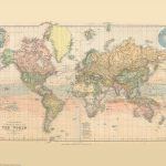 Stanford`s Library Map of the World (1879) – A3 Wall Map, Paper
 World NGS Physical / Ocean Floor Wall Map LARGE PAPER
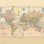 Stanford`s Library Map of the World (1879) – Original Size Wall Map, Paper
Stanford`s Library Map of the World (1879) – A2 Wall Map, Paper – Print on Demand
Stanford`s Library Map of the World (1879) – A1 Wall Map, Paper – Print on Demand
Stanford`s Library Map of the World (1879) – Original Size Wall Map, Paper
Stanford`s Library Map of the World (1879) – A2 Wall Map, Paper – Print on Demand
Stanford`s Library Map of the World (1879) – A1 Wall Map, Paper – Print on Demand
 World Global Mapping Antique Political Wall Map LARGE PAPER
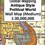
 South East Asia Global Mapping Political Wall Map PAPER
 World Global Mapping Political Wall Map LARGE PAPER
 Hawaii & Honolulu ITMB
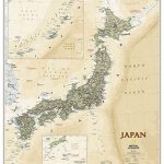 Japan NGS Executive Wall Map PAPER
 Africa NGS Classic Wall Map PAPER
 Hawaiian Islands Borch
 Africa NGS Classic Wall Map LARGE PAPER
 North America NGS Classic Wall Map PAPER
World Global Mapping Political Wall Map MEDIUM PAPER
North America NGS Classic Wall Map PAPER
World Global Mapping Political Wall Map MEDIUM PAPER
 Asia NGS Classic Wall Map PAPER
 North America NGS Classic Wall Map LARGE PAPER
 Asia NGS Executive Wall Map PAPER
 Africa NGS Executive Wall Map PAPER
Hawaii – The Big Island Nelles
Africa NGS Executive Wall Map PAPER
Hawaii – The Big Island Nelles
 North America NGS Executive Wall Map PAPER
 World NGS Explorer Executive Wall Map PAPER
 Hawaii Reise Know-How
 World Maps International Antique Political Wall Map
 Pacific Ocean Floor NGS Wall Map PAPER
 Maine Raven Maps Physical Wall Map PAPER
 World Hemispheres NGS Wall Map PAPER
 Birds of Hawaii & the Tropical Pacific
 France Principal Grape Varieties Wall Map
 California – Hawaii Lighthouses Bella Terra Illustrated Map