Disclosure : This site contains affiliate links to products. We may receive a commission for purchases made through these links.
Hawaii

Related Products:
 Camping Hawaii
 Hawaii Streetwise
 Hawaii – Kauai Nelles
 Birds of Hawaii & the Tropical Pacific
 Light Years: A Girlhood in Hawaii
 National Geographic Hawaii – Published 1960
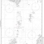
 Admiralty Chart 4807 – San Francisco to Hawaii
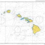
 Admiralty Chart 1309 – Hawaii to Oahu
 Admiralty Chart 1510 – Hawaii to Nihoa
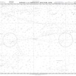 Admiralty Chart 4808 – Hawaii to the Clipperton Fracture Zone
 Resolution: A Novel of Captain Cook`s Adventures of Discovery to Australia, New Zealand and Hawaii, Through the Eyes of George Forster, the Botanist on Board His Ship
 Hawaii Reise Know-How
 Hawaii NGS Wall Map PAPER
 Hawaii NGS Adventure Map 3111
 Hawaii & Honolulu ITMB
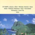
Hawaii – The Big Island Nelles
Hawaii & Honolulu ITMB
Hawaii – The Big Island Nelles
 Hawaii Culture Shock!
 Frommer`s Hawaii 2020
 Insight Guides Hawaii
 Lonely Planet Best of Hawaii
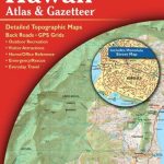 Hawaii Recreational Atlas & Gazetteer
 Hawaii – Oahu – Honolulu Nelles
 DK Eyewitness Travel Guide Hawaii
 Lonely Planet Hawaii the Big Island
 Insight Guides Explore Hawaii
 Hawaii – Travellers` Wildlife Guides
 Hawaii Easy-to-Read Rand McNally
 Hawaii – Maui – Molokai – Lanai Nelles
 Hawaii Raven Maps Physical Wall Map PAPER
 California – Hawaii Lighthouses Bella Terra Illustrated Map