Disclosure : This site contains affiliate links to products. We may receive a commission for purchases made through these links.
Harborne 1901
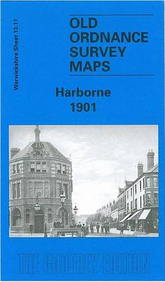
Harborne in 1901 in a fascinating series of reproductions of old Ordnance Survey plans in the Alan Godfrey Editions, ideal for anyone interested in the history of their neighbourhood or family. The map covers the Harborne area of south Birmingham, including a small portion of Edgbaston. Coverage stretches from Beech Lane eastward to York Street and St John`s church, and from Woodbourne Road southward to Greenfield Road. Features include Lordswood House, Oaklands, Queen`s Park, Tally Ho Club Ground, St Joseph`s House, Beech Lanes Farm, Chad Valley Works, Harborne railway branch with terminus, part of Westfield Road, Metchley Abbey (in south-easten corner of map), St John the Baptist`s church, High Street area. On the reverse are a timetable for the Harborne Branch and directory entries for Augustus Road, Clarence Road, Greenfield Road, High Street, Lonsdale Road, Lordswood Road, Station Road, Wentworth Road and Westfield Road. Though the publishers have used the Warwickshire sheet number, this map also covers Staffordshire sheet 72.11 and Worcestershire sheet 5.11. About the Alan Godfrey Editions of the 25″ OS Series:Selected towns in Great Britain and Ireland are covered by maps showing the extent of urban development in the last decades of the 19th and early 20th century. The plans have been taken from the Ordnance Survey mapping and reprinted at about 15 inches to one mile (1:4,340). On the reverse most maps have historical notes and many also include extracts from contemporary directories. Most maps cover about one mile (1.6kms) north/south, one and a half miles (2.4kms) across; adjoining sheets can be combined to provide wider coverage.FOR MORE INFORMATION AND A COMPLETE LIST OF ALL AVAILABLE TITLES PLEASE CLICK ON THE SERIES LINK.

Related Products:
 Harborne South 1901
 Walsall (SE) 1901 – 63.11
Edgbaston 1901
Wath upon Dearne 1901
Mexborough 1901
Walsall (SE) 1901 – 63.11
Edgbaston 1901
Wath upon Dearne 1901
Mexborough 1901
 Newtownards 1901
 Cambridge (North) 1901 – 40.14
Loughborough 1901
Cambridge (North) 1901 – 40.14
Loughborough 1901
 Harborne 1914: Warwickshire Sheet 13.11b
Bridport 1901
Smethwick 1901 – 72.03a
Harborne 1914: Warwickshire Sheet 13.11b
Bridport 1901
Smethwick 1901 – 72.03a
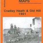 Cradley Heath and Old Hill 1901
Weymouth 1901
Bridgnorth 1901
Wyke Regis 1901
Weymouth Westham 1901
Wolverhampton (SW) 1901 – 62.10
Cradley Heath and Old Hill 1901
Weymouth 1901
Bridgnorth 1901
Wyke Regis 1901
Weymouth Westham 1901
Wolverhampton (SW) 1901 – 62.10
 Walsall (SW) & Pleck 1901 – 63.10a
Bangor East 1901
Walsall (SW) & Pleck 1901 – 63.10a
Bangor East 1901
 Wolverhampton (SE) 1901 – 62.11b
Bearwood 1903
Wolverhampton North West 1901
Donaghadee 1901
Swinton 1901
Dorchester 1901
Wolverhampton (SE) 1901 – 62.11b
Bearwood 1903
Wolverhampton North West 1901
Donaghadee 1901
Swinton 1901
Dorchester 1901
 Harborne 1938
Stourbridge (North) & Amblecote 1901 – 4.10a
Horsehay and Dawley 1901
Harborne 1938
Stourbridge (North) & Amblecote 1901 – 4.10a
Horsehay and Dawley 1901
 Kiveton Park and Wales 1901
 Sedgley South-East with Swan Village and West Coseley 1901
Kilnhurst 1901
Ely 1901 – 26.14
Dundee West 1901
Sedgley South-East with Swan Village and West Coseley 1901
Kilnhurst 1901
Ely 1901 – 26.14
Dundee West 1901
 Tickhill 1901
Bangor West 1901
Tickhill 1901
Bangor West 1901
 Whitstable (North) 1906 – 23.10
 Whitstable West 1905
Bedford 1924 – 11.16b
Whitstable West 1905
Bedford 1924 – 11.16b
 Whitstable East 1906
Stourport 1901
Whitstable East 1906
Stourport 1901