Disclosure : This site contains affiliate links to products. We may receive a commission for purchases made through these links.
Hanover – Hildesheim – Celle ADAC Street Atlas
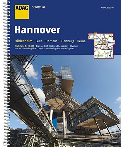
Hannover – Hildesheim Region Street Atlas in a series of detailed atlases covering the whole of Germany at 1:20,000 with UTM coordinates for GPS navigation, postal codes and public transport, published by ADAC, the country’s largest motoring organization. The plans name all the individual streets and indicate all the main landmarks and public buildings. All public transport facilities are shown: buses, trams, underground and overland rail lines, with separate plans of the rail networks. One way streets and car parks are marked.The plans also show postal divisions and have extensive street indexes which, where appropriate, show individual postal codes for each street. Enlargements cover central areas in main cities in greater detail. Each atlas also includes road maps at 1:100,000 and/or 1:200,000. Map legends include English.*In this title:* the area around the towns of Hannover, Hildesheim, Celle, Hameln, Nienburg, Peine and Salzgitter.

Related Products:
 Hamburg – Lรผbeck – Lรผneburg ADAC Street Atlas
 Saarland – West Palatinate ADAC Street Atlas
 Berlin – Potsdam Region ADAC Street Atlas
Rhine-Main – Frankfurt – Aschaffenburg – Darmstadt – Mainz – Wiesbaden ADAC Street Atlas
Berlin – Potsdam Region ADAC Street Atlas
Rhine-Main – Frankfurt – Aschaffenburg – Darmstadt – Mainz – Wiesbaden ADAC Street Atlas
 Cologne – Bonn – Aachen – Koblenz – Leverkusen ADAC Street Atlas
 Munich – Augsburg – Erding – Ingolstadt – Landshut ADAC Street Atlas
 Nuremberg – Ansbach – Bamberg – Bayreuth – Erlangen – Fรผrth ADAC Street Atlas
 Stuttgart – Heilbronn – Gรถppingen – Pforzheim – Reutlingen – Rottweil ADAC Street Atlas
 East Westphalia – Lippe – Bielefeld – Detmold – Gรผtersloh – Minden – Paderborn ADAC Street Atlas
 Rhine-Ruhr – Bochum – Dortmund – Duisburg – Essen – Mรผnster ADAC Street Atlas
Germany: ADAC Regional Street Atlases
Rhine-Ruhr – Bochum – Dortmund – Duisburg – Essen – Mรผnster ADAC Street Atlas
Germany: ADAC Regional Street Atlases
 Hildesheim EXTRA
 Hanover Falk EXTRA Street Plan
 Hanover EXTRA
 Celle EXTRA
Frankfurt am Main Falk EXTRA Street Plan
Celle EXTRA
Frankfurt am Main Falk EXTRA Street Plan
 Hanover Falk Cityplan
Bremen Falk EXTRA Street Plan
Trier Falk EXTRA Street Plan
Hannover Falk Special Fold Plan
Hanover Falk Cityplan
Bremen Falk EXTRA Street Plan
Trier Falk EXTRA Street Plan
Hannover Falk Special Fold Plan
 Frankfurt am Main
Nuremberg Falk EXTRA Street Plan
Frankfurt am Main
Nuremberg Falk EXTRA Street Plan
 Ulm – Neu-Ulm Extra
 Gรถttingen EXTRA
Lรผbeck EXTRA
Monchengladbach EXTRA
Munster EXTRA
Saarbrucken EXTRA
Oldenburg EXTRA
Gรถttingen EXTRA
Lรผbeck EXTRA
Monchengladbach EXTRA
Munster EXTRA
Saarbrucken EXTRA
Oldenburg EXTRA
 Bayreuth Extra
Bremerhaven EXTRA
Bayreuth Extra
Bremerhaven EXTRA
 Dresden EXTRA
Gelsenkirchen EXTRA
Ingolstadt EXTRA
Cologne EXTRA
Marburg EXTRA
Dresden EXTRA
Gelsenkirchen EXTRA
Ingolstadt EXTRA
Cologne EXTRA
Marburg EXTRA
 Potsdam EXTRA
Stralsund EXTRA
Potsdam EXTRA
Stralsund EXTRA
 Stuttgart EXTRA
Augsburg EXTRA
Stuttgart EXTRA
Augsburg EXTRA