Disclosure : This site contains affiliate links to products. We may receive a commission for purchases made through these links.
Hammerfest Hiking Set: Kvasund, Hasvik & Alta Communes
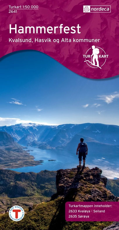
Hammerfest Hiking Set covering the Kvasund, Hasvik and Alta Communes, with two Turkart maps at 1:50,000: Kvayรธla- Seiland and Sรธrรธya. Maps in the Turkart series have cartography based on the Norwegian topographic survey and are overprinted with hiking routes and other tourist information. The base map is derived from the standard 1:50,000 topographic survey series. Contours lines are drawn at 20m intervals. The overprint varies from title to title, but includes local footpaths, in some cases distinguishing between easy and more difficult trails, as well as mountain huts and campsites. Many titles also indicate cycle or ski routes, other accommodation possibilities, sport and recreational facilities, places of interest, etc. The maps have a UTM grid and margin ticks giving latitude and longitude. Map legend includes English. Several titles have on the reverse additional tourist information, although in most cases in Norwegian only.PLEASE NOTE: to see the list of Turkart map sets and links to Turkart series at 25K, 50K and 100K please click on the series link above.

Related Products:
 Kvayรธla – Seiland – Hammerfest Municipality Nordeca 2633
 Norway: Turkart 50K Topographic Hiking Maps
 Norway: Turkart 100K Topographic Hiking Maps
 Norway: Turkart 25K Topographic Hiking Maps
 Huldreheimen Nordeca 2489
 Fjordruta Nordeca 2607
 Forollhogna Nordeca 2731
 Hardangervidda East Nordeca 2556
 Hardangervidda West Nordeca 2558
 Lofoten Nordeca 2549
 Blefjell Nordeca 2207
 Lifjell Nordeca 2219
 Jotunheimen Nordeca 2215
 Femunden Nordeca 2559
 Rondane Nordeca 2716
 Rendalen Nordeca 2753
 Hjelmelandsheiane Nordeca 2232
 Finnemarka Nordeca 2221
 Indre Ryfylke Nordeca 2790
 Besseggen Nordeca 2649
 Gullfjellet Nordeca 2713
 Glittertinden Nordeca 2757
 Suldalsheiene Nordeca 2228
 Folgefonna – Hardangerfjorden Nordeca 2431
 Indre Sunnfjord Nordeca 2481
 Galdhopiggen Nordeca 2655
 Gaustatoppen Nordeca 2657
 Hurrungane Nordeca 2758
 Geirangerfjorden Nordeca 2760
 Snรธheim Nordeca 2784
 Dovrefjell East – Knutsรธ Nordeca 2710
 Geilo Nordeca 2515
 Hallingskarvet Nordeca 2517
 Sveio Nordeca 2813
 Jรธlster Nordeca 2568
 Reineskarvet Nordeca 2385
 Tafjordfjella Nordeca 2533
 Trondheim Nordeca 2665
 Lysefjorden Nordeca 2681
 Skarverennet Nordeca 2703