Disclosure : This site contains affiliate links to products. We may receive a commission for purchases made through these links.
Hadrian`s Wall Path A-Z Adventure Atlas
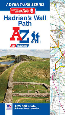
The A-Z Adventure Series of maps combines the best of OS and A-Z, creating the perfect companion for walkers, off-road cyclists, horse riders and anyone wishing to explore the great outdoors. Hadrian`s Wall Path is a National Trail which follows the line of Hadrian`s Wall from coast-to-coast.The 84 mile (135km) path weaves through beautiful countryside, encountering historic remains of Roman forts and milecastles, splendid bridges, views from the Whin Sill escarpment and Solway salt marshes. Starting in Wallsend in Newcastle and ending in Bowness-on-Solway, the route on the map is clearly highlighted in yellow with mileage markers added to guage distances when planning sections of the walk to enjoy.This official National Trail Map of Hadrian`s Wall Path features 38 pages of continuous Ordnance Survey Explorer mapping, providing complete coverage of the Hadrian`s Wall Path. The atlas includes a route planner showing distances between places and the amenities available, featuring: Information Centres, Hotels/B&Bs, Youth Hostels, Campsites (seasonal opening), Public Houses, Shops, Restaurants, Cafes (seasonal opening) and Petrol Stations. Also featured is advice on safety and security when walking and a selection of QR codes linked to useful websites, including temporary route updates from the National Trails, regional information, map reading advice and weather reports.Unlike the original OS sheets, this A-Z Adventure Atlas includes a comprehensive index to towns, villages, hamlets and locations, natural features, nature reserves, car parks and youth hostels, making it easy to find the required location quickly. Each index entry has a page reference and a six figure National Grid Reference. With a book size of 240mm x 134mm it is the same size as a standard OS Explorer map when closed.

Related Products:
 South West Coast Path 2 – North Cornwall A-Z Adventure Atlas
 Norfolk Coast Path and Peddars Way A-Z Adventure Atlas
 Hadrian`s Wall Path – 3rd ed.
 Hadrian`s Wall Path – Easy-to-use Folding Map and Essential Information
 Hadrian`s Wall Path Cicerone Map Booklet
 England Coast Path – Camber to Folkestone Adventure Map
 Trekking the Hadrian`s Wall Path (National Trail Guidebook with OS 1:25k maps): Two-way guidebook: described east-west and west-east
 Hadrian`s Wall Path
 Yorkshire Wolds Way Adventure Atlas
 Cleveland Way A-Z Adventure Atlas
 Glyndwr`s Way Adventure Atlas
 Hadrian`s Wall Path Harvey National Trail XT40
 England Coast Path Adventure Map – Minehead to Brean Down
 South West Coast Path 5 – Dorset A-Z Adventure Atlas
 South West Coast Path 1 – North Devon & Somerset A-Z Adventure Atlas
 South West Coast Path 3 – South Cornwall A-Z Adventure Atlas
 South West Coast Path 4 – South Devon Adventure Atlas
 John Muir Way A-Z Adventure Atlas
 Hadrian`s Wall History & Guide
 Hadrian`s Wall Archaeological Map
 Hadrian`s Cycleway: Coast-to-coast cycling from Ravenglass to South Shields
 Pennine Way North A-Z Adventure Atlas
 Pembrokeshire Coast A-Z Adventure Atlas
 South West Coast Path 1 – Minehead to St Ives Cicerone Map Booklet
 Llyn Peninsula Coastal Path – Wales Coast Path Map-Booklet
 Hadrian`s Wall – History and Guide
 South West Coast Path 2 – St Ives to Plymouth Cicerone Map Booklet
 The England Coast Path: 1,000 Mini Adventures Around the World`s Longest Coastal Path
 Walking in Northumberland: 36 walks throughout the national park – coast, Cheviots, Hadrian`s Wall and Pennines
 South West Coast Path 3 – Plymouth to Poole Cicerone Map Booklet
 Snowdonia A-Z Adventure Atlas
 Exmoor A-Z Adventure Atlas
 Hadrian`s Wall – Haltwhistle & Hexham OS Explorer OL43
 Hadrian`s Wall: An Archaeological Walking Guide
 Thames Path A-Z National Trail Road Map
 Hadrian`s Wall – Haltwhistle & Hexham OS Explorer OL43 ACTIVE
 Lake District – Northern Fells Adventure Atlas
 Hadrian`s Wall
 Cornwall Coast Path – Bude to Plymouth (South West Coast Path Part 2)
 Pennine Way South A-Z Adventure Atlas