Disclosure : This site contains affiliate links to products. We may receive a commission for purchases made through these links.
Hadrian`s Cycleway Sustrans Cycle Route Map
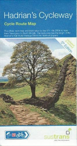
The official route map and information for the 174 mile (280 km) route from Ravensglass to South Shields – Sustrans` route NN72. The route stretches the length of the Hadrian`s Wall World Heritage Site in the north of England. In a 1:100,000 scale, the map shows gradient profiles and visitor information, with detailed routes through towns and cities.The route has been developed by Sustrans and offers a cycling adventure with magnificent coastal views through wonderful countryside, Roman forts and museums, inspiring modern attractions, quaint villages and attractive market towns – all enjoyed from cycle paths, country lanes and quieter roads. The route is waymarked with the familiar blue Sustrans` signs. Most people are able to complete the route in three days, but for those wanting to stop at the numerous attractions along the way it is likely to take 4-5 days.

Related Products:
 Tyne & Wear Sustrans Cycle Map 34 – incl. the Sea to Sea, Hadrian`s Cycleway, Reivers Route
 Pennine Cycleway North Sustrans Cycle Route Map
 Shakespeare Cycleway Sustrans Cycle Route Map
 Pennine Cycleway South Sustrans Cycle Route Map
 Great Western Way Sustrans Cycle Route Map
 The Bay Cycle Way Sustrans Cycle Route Map
 Bath to Bournemouth Sustrans Cycle Route Map
 Celtic Trail Sustrans Cycle Route Map
 London to Brighton Sustrans Cycle Route Map
 The Varsity Way Sustrans Cycle Route Map
 Way of the roses: The official guide to the national cycle network coast to coast cycle route from Morecambe to Bridlington
 South Coast East Sustrans Cycle Route Map
 Lรดn Las Cymru North Sustrans Cycle Route Map
 The Fens Sustrans Cycle Map 20 – Norfolk Coast Cycleway – Peterborough`s Green Wheel
 Suffolk – Ipswich – Bury St Edmunds – Felixstowe – Suffolk Coast Cycle Route Sustrans Cycle Map 18
 South Coast West Sustrans Cycle Route Map
 Merseyside & Manchester – Pennine Cycleway – The Trans Pennine Trail Sustrans Cycle Map 25
 Central Sussex & South Surrey Sustrans Cycle Map 7
 The Ultimate UK Cycle Route Planner
 Lรดn Las Cymru South Sustrans Cycle Route Map
 Hadrian`s Cycleway: Coast-to-coast cycling from Ravenglass to South Shields
 North Wales – Lon Eifion – Lon Las Cefni – North Wales Coast Route Sustrans Cycle Map 24
 Lincolnshire and Wolds Sustrans Cycle Map 27
North Northumberland & Scottish Borders Sustrans Cycle Map 39
Lincolnshire and Wolds Sustrans Cycle Map 27
North Northumberland & Scottish Borders Sustrans Cycle Map 39
 The Causeway Coast & Glens Cycle Map 52 Sustrans
 Lanarkshire & Scottish Borders 110K Sustrans Cycle Map No. 38
County Durham & North Yorkshire Sustrans Cycle Map 32
Hampshire & Isle of Wight Sustrans Cycle Map 6
Lanarkshire & Scottish Borders 110K Sustrans Cycle Map No. 38
County Durham & North Yorkshire Sustrans Cycle Map 32
Hampshire & Isle of Wight Sustrans Cycle Map 6
 Land`s End to John O`Groats – On the National Cycle Network: Official Sustrans Guide
Yorkshire Wolds, York & the Humber Sustrans Cycle Map 28
Land`s End to John O`Groats – On the National Cycle Network: Official Sustrans Guide
Yorkshire Wolds, York & the Humber Sustrans Cycle Map 28
 North Cumbria & Dumfries 110K Sustrans Cycle Map No. 35
 Derry ~ Londonderry & The North West Cycle Map 51 sustrans
 Devon North Sustrans Cycle Map 3 – Including the Tarka Trail
 Lancashire Sustrans Cycle Map 30
 Warwickshire & South Midlands 110K Sustrans Cycle Map No. 16
 Aberdeenshire 110K Sustrans Cycle Map No. 45
 Dundee, Angus & North Fife 110K Sustrans Cycle Map No. 44
London Sustrans Cycle Map 53
Dundee, Angus & North Fife 110K Sustrans Cycle Map No. 44
London Sustrans Cycle Map 53
 East Midlands 110K Sustrans Cycle Map No. 21