Disclosure : This site contains affiliate links to products. We may receive a commission for purchases made through these links.
Hackney 1893 – 41.2
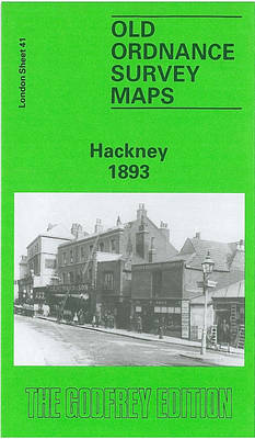
Hackney in 1893 in a fascinating series of reproductions of old Ordnance Survey plans in the Alan Godfrey Editions, ideal for anyone interested in the history of their neighbourhood or family. Three versions of this map have been published to show how the area developed across the years, stretching from Mare Street eastward to White Post Lane, and from Tresham Avenue and Ashenden Road southward to Victoria Park Road. Features include much of Victoria Park, Hackney Cut Navigation, Hertford Union Canal, Hackney Common, Well Street, Wick Road, Hackney Wick, South Hackney, Homerton; Victoria Park, Homerton and Hackney stations; City of London Union Workhouse (later Institution), Hackney Workhouse, Eastern Fever Hospital, chemical works and factories at the east edge of map, St Thomas`s Square, St John of Jerusalem church, St John`s church, French Hospital, site of Rowe Chapel, Town Hall, Old Town Hall. The 1870 map is especially attractive, notably portraying South Hackney with its leafy gardens.About the Alan Godfrey Editions of the 25″ OS Series:Selected towns in Great Britain and Ireland are covered by maps showing the extent of urban development in the last decades of the 19th and early 20th century. The plans have been taken from the Ordnance Survey mapping and reprinted at about 15 inches to one mile (1:4,340). On the reverse most maps have historical notes and many also include extracts from contemporary directories. Most maps cover about one mile (1.6kms) north/south, one and a half miles (2.4kms) across; adjoining sheets can be combined to provide wider coverage.FOR MORE INFORMATION AND A COMPLETE LIST OF ALL AVAILABLE TITLES PLEASE CLICK ON THE SERIES LINK.

Related Products:
 Hackney 1870 – 41.1
 Hackney 1913 – 41.3
 Ealing 1913
Devonport North 1893
Plymouth North 1893
Ealing 1913
Devonport North 1893
Plymouth North 1893
 Kingston upon Thames 1895 – 6.16
 Shoreditch 1893 – 51.2
 Victoria Park 1889
Harton 1895
Victoria Park 1889
Harton 1895
 Bethnal Green & Bow 1914 – 52.3
 Bethnal Green & Bow 1894 – 52.2
Bethnal Green & Bow 1870 – 52.1
Bethnal Green & Bow 1894 – 52.2
Bethnal Green & Bow 1870 – 52.1
 Morningside 1893 – 3.15
 St. Andrews 1893 – 9.10
 Upper Edmonton 1894 – 3a
 Croydon NW 1895 – 154
Leytonstone 1893 – 23.2
Chelsea 1913 – 87.3
Chelsea 1865 – 87.1
Croydon NW 1895 – 154
Leytonstone 1893 – 23.2
Chelsea 1913 – 87.3
Chelsea 1865 – 87.1
 Chelsea & West Brompton 1894 – 87.2
Redruth 1906
Chelsea & West Brompton 1894 – 87.2
Redruth 1906
 Wolverhampton (SE) 1901 – 62.11b
West Bromwich 1902 – 68.10b
Wolverhampton (SE) 1901 – 62.11b
West Bromwich 1902 – 68.10b
 Sheffield Longley 1902
Accrington 1909
Loughborough 1901
Anfield 1908 – 106.07b
Tranmere & Oxton 1909
Manchester North West and Central Salford 1915
Sheffield Longley 1902
Accrington 1909
Loughborough 1901
Anfield 1908 – 106.07b
Tranmere & Oxton 1909
Manchester North West and Central Salford 1915
 Walsall (SW) & Pleck 1901 – 63.10a
Lanark 1896 – 25.15
Harborne South 1901
Ipswich South-West 1902
Wolverhampton North West 1901
Walsall (SW) & Pleck 1901 – 63.10a
Lanark 1896 – 25.15
Harborne South 1901
Ipswich South-West 1902
Wolverhampton North West 1901
 Altrincham 1908
Torquay 1904
Altrincham 1908
Torquay 1904
 Paddington 1893 – 60.2
Oxford, Witney and District 1893
Ipswich 1902 – 75.11
Paddington 1893 – 60.2
Oxford, Witney and District 1893
Ipswich 1902 – 75.11
 Wandsworth Common 1893 – 124b