Disclosure : This site contains affiliate links to products. We may receive a commission for purchases made through these links.
Gruppi Argentera e Marguareis Edizioni Multigraphic 109/115
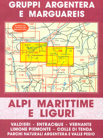
Gruppi Argentera e Marguareis, map no. 109/115 at 1:25,000 from Edizioni Multigraphic covering the Italian Alps along the southern part of the border between Piedmont and France, south of Cuneo. Coverage includes the Pallanfre Reserve, Colle di Tenda / Col de Tende, and Parco Naturale Valle Pesio. Map corners give latitude and longitude based on Greenwich. The map includes a list of refuges highlighted on the map (text in Italian). Map legend includes English.Maps in this series from Edizioni Multigraphic cover Ligurian Alps and the coast, the crest of the Apennines along the border of Tuscany with its neighbouring regions, and parts of Tuscany itself. Most maps have contours at 25-metre intervals, with colouring for forests and some relief shading. The cartography is rather old fashioned and sometimes not as clear as in other map series. An overprint highlights hiking paths, including all the popular long-distance routes such as Garfagnana Trekking, Alta Via dei Monti Liguri and the GEA – Grande Escursione Appenninica, the main path over the crests of the Apennines. The overprint also shows campsites and, where appropriate, mountain refuges and other types of alpine accommodation. Most of the maps are double-sided, as indicated by the map number. Each map covers approximately 26 x 17km / 16 x 11 miles per side. Some of the maps indicate latitude and longitude at the map corners, but with longitude sometimes based on Rome rather than Greenwich. Map legends vary, most maps include English. Please check individual descriptions for exact details.To see the other titles in this series please click on the series link.

Related Products:
 Appennino Bolognese e Pistoiese Edizioni Multigraphic 21
 Appennino Pistoiese – Monti Pesciatini Edizioni Multigraphic 22
 Alpi Apuane Edizioni Multigraphic 101/102
Imperia – San Remo – Ventimiglia Edizioni Multigraphic 111/112
Alpi Apuane Edizioni Multigraphic 101/102
Imperia – San Remo – Ventimiglia Edizioni Multigraphic 111/112
 Appennino Bolognese e Pratese Edizioni Multigraphic 23
 Appennino Cesenate – Val Tiberina Edizioni Multigraphic 34/36
 Appennino Pistoiese e Modenese Edizioni Multigraphic 19
 Media Valle del Serchio – Garfagnana – Val di Lima Edizioni Multigraphic 20
 Chianti – Florence and Siena Edizioni Multigraphic 42/43
Appenninno Reggiano – Alta Garfagnana Edizioni Multigraphic 16
Alto Frignano – Appennino Modenese Edizioni Multigraphic 17
Chianti – Florence and Siena Edizioni Multigraphic 42/43
Appenninno Reggiano – Alta Garfagnana Edizioni Multigraphic 16
Alto Frignano – Appennino Modenese Edizioni Multigraphic 17
 Appennino Reggiano – Lunigiana – Garfagnana Edizioni Multigraphic 15
 Appenninno Parmense, Reggiano – Alta Lunigiana Edizioni Multigraphic 14
Valle di Roja – M. Toraggio – M. Grammondo Edizioni Multigraphic 113/114
Appennino Parmense – Alta Lunigiana Edizioni Multigraphic 9
Appenninno Parmense, Reggiano – Alta Lunigiana Edizioni Multigraphic 14
Valle di Roja – M. Toraggio – M. Grammondo Edizioni Multigraphic 113/114
Appennino Parmense – Alta Lunigiana Edizioni Multigraphic 9
 Appennino Parmense – Alta Lunigiana Edizioni Multigraphic 13
 Monti Sibillini National Park Edizioni Multigraphic 60/61
Italy: Edizioni Multigraphic 25K Walking Maps of Central Italy
Monti Sibillini National Park Edizioni Multigraphic 60/61
Italy: Edizioni Multigraphic 25K Walking Maps of Central Italy
 Livorno Coast Edizioni Multigraphic 523
 Siena and Crete – Senesi West Edizioni Multigraphic 517
Riviera di Levante – Portofino – Golfo di Tigullio – Golfo Paradiso Edizioni Multigraphic 6
Siena and Crete – Senesi West Edizioni Multigraphic 517
Riviera di Levante – Portofino – Golfo di Tigullio – Golfo Paradiso Edizioni Multigraphic 6
 Parco Regionale Migliarino – S. Rossore – Massaciuccoli Edizioni Multigraphic 503
 Versilia – Riviera Apuana – Alpi Apuane Edizioni Multigraphic 711
Monte Amiata 25K Ed. Multigraphic Map No. 41
Genoa – Varazze 25K Ed. Multigraphic Map No. 3/4
Casentino – Val Tiberina 25K Ed. Multigraphic Map No. 35
Massiccio del Pratomagno 25K Ed. Multigraphic Map No. 31/32
Alto Mugello – Appennino Bolognese Edizione Multigraphic 25
Florence – Mugello – Lago di Bilancino 25K Ed. Multigraphic Map No. 27
Valli del Bormida – Appennino Savonese 25K Ed. Multigraphic Map No. 1/2
Versilia – Riviera Apuana – Alpi Apuane Edizioni Multigraphic 711
Monte Amiata 25K Ed. Multigraphic Map No. 41
Genoa – Varazze 25K Ed. Multigraphic Map No. 3/4
Casentino – Val Tiberina 25K Ed. Multigraphic Map No. 35
Massiccio del Pratomagno 25K Ed. Multigraphic Map No. 31/32
Alto Mugello – Appennino Bolognese Edizione Multigraphic 25
Florence – Mugello – Lago di Bilancino 25K Ed. Multigraphic Map No. 27
Valli del Bormida – Appennino Savonese 25K Ed. Multigraphic Map No. 1/2
 Appennino Modenese – Garfagnana Edizione Multigraphic 18
 Florence and Surroundings Edizioni Multigraphic 510
Mugello – Val di Sieve – Monte Falterona 25K Ed. Multigraphic Map No. 30
Florence and Surroundings Edizioni Multigraphic 510
Mugello – Val di Sieve – Monte Falterona 25K Ed. Multigraphic Map No. 30
 Parco della Maremma – Monti dell`e Uccellina Edizioni Multigraphic 504
Riviera di Ponente: Albegna to Diano Marina 25K Ed. Multigraphic Map No. 106
Parco della Maremma – Monti dell`e Uccellina Edizioni Multigraphic 504
Riviera di Ponente: Albegna to Diano Marina 25K Ed. Multigraphic Map No. 106
 Garfagnana Edizioni Multigraphic 701
Mugello – Alto Mugello 25K Ed. Multigraphic Map No. 28
Garfagnana Edizioni Multigraphic 701
Mugello – Alto Mugello 25K Ed. Multigraphic Map No. 28
 Chianti – Val di Pesa – Val d`Elsa Edizioni Multigraphic 512
Alto Casentino – Valli del Bidente 25K Ed. Multigraphic Map No. 33
Chianti – Val di Pesa – Val d`Elsa Edizioni Multigraphic 512
Alto Casentino – Valli del Bidente 25K Ed. Multigraphic Map No. 33
 Volterra and its Environs Edizioni Multigraphic 513